The Saturday before Easter we assembled a strong team of paddlers from all over the state and headed south into the Little River drainage. We had a total of six boaters, which is the critical mass for carnage by most estimates...
Mike had been mailing us all week raving about the Little River, which rushes down out of the Cascades at a respectable 120 fpm gradient. There were also a bunch of steep side creeks we were interested in, but the Little ended up occupying most of our day. We put on at the road 165 bridge and bounced down a few shallow gravel bars and then immediately had to portage a log. "More water, less wood!" somebody grumbled.
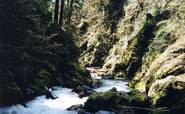
I had seen a mean looking class V about a half mile down during the shuttle so we ran the rapids above it carefully, with Gabe Flock probing. Finally the river plunged out of sight into a jumble of boulders and I signalled Gabe that we had arrived. We got out and scouted, and none of us liked what we saw- a very difficult lead in to a nasty looking waterfall. Gabe was the only one of us seriously thought about running it, but in the end he regretfully shouldered his boat and sweated through the long portage like the rest of us. I think at higher water this drop would become much easier.
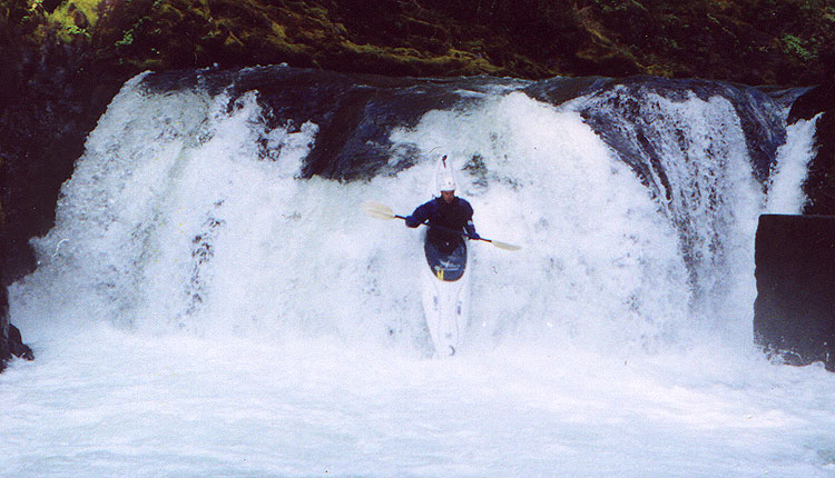
Steve Stuckmeyer with the exit falls on the first big drop in the background.
Below here the river alternated between small boulder gardens and gravel bars, and we definitely could have used a bit more water. Finally we arrived at the next horizon line and we got out to scout. Once again, we were confronted with a drop that would have been easier with more water, and once again, everyone shouldered their boats except Gabe. This rapid was ugly- a fast chute blasted down into a rock wall on the left where the current piled up onto an undercut boulder and then tore through a bouldery runout. Only Gabe ran this one, bouncing and sliding down the chute and careening off of the pillow next to the undercut. From my vantage point downstream it looked like he went into the undercut, but he popped out a second after I snapped a picture...
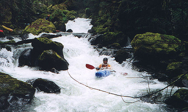
We continued downstream and just when I started to wonder if I was going to get to run any good drops the next horizon line appeared. We scouted and were pleased to see the first sweet drop of the day, an eight foot ledge that required a tricky twisting boof to the right to keep from smashing into the rock on the far side. John Whaley and I ran this one a couple of times as 'fun insurance' just in case it was the last good drop of the day! (FYI: this ledge is severely backcut. From my photo taking vantage I could see at least six feet under the shelf.)
Gabe twists to avoid the rock at the first ledge.
Below this drop the river narrowed dramatically and entered a deep gorge. As we worked our way down the rapids steepened and (unfortunately) the logs increased.
I was just starting to wonder what would happen if we ran into an unrunnable, unportagable drop when all hell broke loose. Gabe and Steve were probing far out in front when Steve dropped into a narrow chute in the middle of a log jam and was vertically pinned. He was ok, but a little more water on that side and it would have been very serious. His boat was pretty well stuck after he climbed out of it, but we were in no position to help. When Steve got into trouble we were upstream prying a boat off of a midstream boulder at the top of the logjam. Mike had flipped in a drop above the logs and bailed, fearing that he would be swept downstream into the jam. Meanwhile, I sat in the eddy at the top of the gorge while Mike, John, and Pete freed the boat so I could run the first drop above the logs. We regrouped and rounded the corner only to find an even bigger log jam with two tiny figures down in the middle of it pulling on something with a rope. By the time we worked our way down through the maze of logs Gabe and Steve had freed Steves boat and we began a long portage around the final logjam.
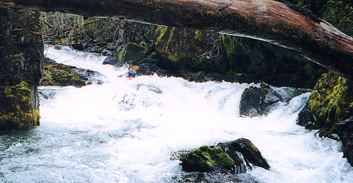
The next major drop was in my opinion the best on the river and was very similar to the first ledge, only more difficult. This time there was a boulder sieve on the river left side just waiting to catch the unwary paddler, so this one too required a strong midair turn to land in the channel pointing right and avoid getting pushed into the sieve. I was thoroughly enjoying myself after this one!
Gabe runs the second ledge. The boulder sieve is visible in the bottom right hand side of the picture.
(Note: If you find the turnoff that leads to the bridge over Black Creek Falls you should be able to return to the main road, drive upstream about 2/10ths of a mile, and locate this ledge. This is a good alternate put in if you don't want to deal with the woody mess in the gorge... )
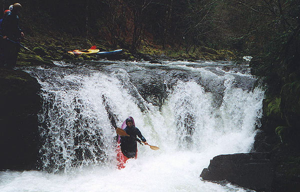
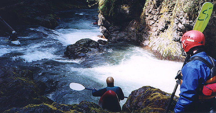
Just downstream was the confluence of Black Creek and another nasty falls that we seal launched around. Just downstream of this falls is another nice ledge drop pictured here. Once again, I think Black Creek Falls would be significantly easier with more water.
Mike looks on while John seal launches, Pete ponders the next drop, and Steve and Gabe wait in the pool below.
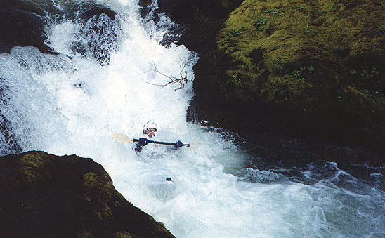
Below Black Creek Falls we encountered a final log choked drop that we portaged and then the river was free of wood (I suspect very little makes it past that gorge). It also became less continuous, with deep, green pools between short, powerful drops. This part of the run was also the most scenic, with old growth trees clinging precariously to the mossy rock walls. Slowly our portaging angst melted away as we ran one sweet drop after another. A couple of drops stand out- one short powerful ledge had a deep, narrow slot in the middle that Steve disappeared into and then popped out downstream with his eyes wide and a 'what the hell was that?!?' look on his face. The rest of us ran this one far left to stay out of the slot after Steve said he hit his elbow on something in there. If you look carefully at this photo of Pete you can just see the slot in the middle of the ledge that devoured Steve...
Just downstream was a twisty chute that dumped into a chomping, narrow hole that looked ugly so we portaged- at least most of us did. While the rest of us were hiking downstream with our boats Pete jumped into his and ran it before we knew what he was doing. I was downstream when I heard somebody yell and I saw Pete come rocketing out of the narrow slot upside down. He cleared the hydraulic and rolled up, shrugging his shoulders as if to say 'that wasn't my best line..'
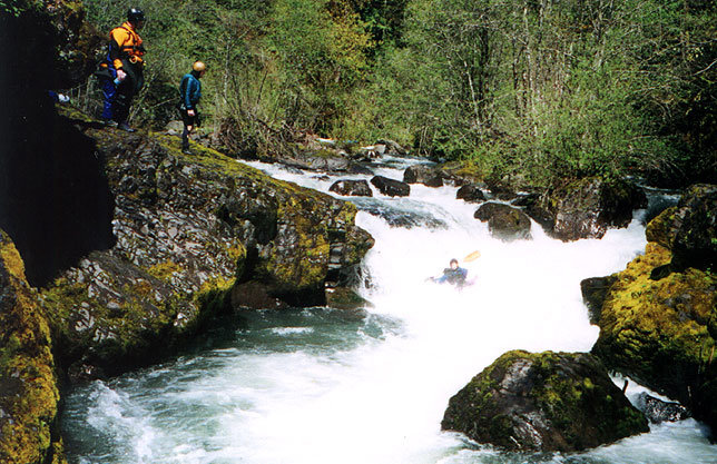
Finally we arrived at a very well defined horizon line and I could hear the tell-tale thunder of a waterfall. I got out of my boat and ran downstream and started jumping up and down with glee at this totally unexpected find. The falls was really nice, with a perfect boof platform on the left or a vertical plunge in the middle. Everybody ran this one, and it was so good John and I couldn't resist hauling our boats back upstream for a second trip! Immediately below the falls is a tricky ledge that has a nice boof on the left. I boofed hard, landed on a boulder that had been invisible from upstream, and promptly fell back into the hole, which grabbed me and surfed me backwards into the right wall. I came out with a paddle stroke, but I imagine if the flow had been much higher it wouldn't have let me go so easily! The takeout was just downstream of here and we were pretty glad to end the day on such a positive note. I look forward to heading down into the Little River drainage again...
Pete sails over Little River Falls