
By Steve Stuckmeyer
The 240 fpm section on the NFMF known as the 'Miracle Mile' is one of my favorite runs. It's only 45 minutes from Eugene, and it almost always has enough water to boat. However, it is a river with multiple personalities depending upon how far up it is on the painted gauge on the Christy Creek Bridge.
From flows of minus 6 inches to about plus 8 inches, the run feels like a steep creek; it's a boulder slalom through non-stop class III+ to IV+ rapids. If you're not very comfortable with rocky, extremely technical water then its going to feel like class V. Often, as soon as you've landed in the eddy from one 3-foot drop, you are looking right over the edge of the next 2 to 3 foot drop.
At flows of perhaps 9 inches to 1.5 feet, it begins to feel like a river and the water really starts to pick up steam. At these flows individual rapids probably deserve a IV+ to V rating, and if you're not feeling comfortable it's going to seem a lot harder.
And finally at flows over 1.5 feet, the Mile has become a non-stop gauntlet of technical maneuvering to avoid big rocks and bigger holes. All but the biggest eddies will have become the backwash of holes. This is powerful class V, and if you are over you head its going to be brutal. Some regulars run this thing really high, but if the gauge is over 2 feet you'd better eat your Wheaties! And if you're feeling intimidated by the bottom of 'Initiation' then I'd suggest hiking up to the road!
This particular trip occurred in the low-water winter of 2000-01. It was January and we had all been thirsting for creek runs, unfortunately nothing was going. Nothing that is, except the North Fork of the Middle Fork of the Willamette's MIRACLE MILE. Pat Welch's calculation suggested we'd find about 550 cfs at the confluence with the Middle Fork. It had been dry and warm so we suspected much of the water was coming down from high in the drainage, and we were pleased to find about 6 inches on the gauge (maybe 400 cfs?). We had amassed a group of 5 local paddlers (Tom Powers, Mike Haley, Brad Cascagnette, Gabe Flock, and myself), some of whom have long class V resumes, and some who tend to conservatively stay around the class IV+ mark. It was warm, sunny, and many of us hadn't been boating much. We jokingly suggested it might be a day filled with humorous carnage as we ran laps on the Mile. It turns out we weren't disappointed.
The first obstacle is the logjam just above the first bridge. It might look unsettling, but trust me; there's an easy move down the chute under the left side of the jam followed by a small class II+ rock garden lying under and just below the bridge. There's also another painted gauge on the right pillar of this bridge. The blue mark means its low, green means optimal, and I'm sure you can guess what red means!
Below the bridge, the river bends to the left and the hazing begins at 'Initiation'. This is a long series of easily boat-scoutable 2 and 3 foot drops that continues for about 200 yards. Watch out for the big log that leans into the main current just below the first drop. I'd recommend running up against the logjam on the right, and then pulling a tight right turn behind a big rock before sliding over a slightly covered boulder and under the log. Don't miss that turn! If you do, you might join the woody mess that's accumulating up against the underwater portion of that log. (At higher flows you can run along the left bank, and just left of this log.)
After you've been initiated, the river bends back to the right and bounces through the rocky drop known as 'Ricochet'. At low flows you'll recognize how this bouldery drop got its name. The trick is to run down the main flow, watch out for a pin rock below what appears to be the first boof (angle left), and then slide just to the right of the biggest rock in the center of the rapid. Finally just keep your boat upright and pointed straight ahead as you careen down the remaining 6-foot boulder sluice! You'll be deposited in a large eddy up against the right bank. Run the next drop in the middle and get ready for the fun to begin!
At the next big eddy on the right bank you've come to the top of 'Confusion'. It's the longest distinguishable rapid on the Mile, and if you want to scout the whole thing from shore the left bank is your best bet. 'Confusion' starts with a narrow slot on the right that I always scout the first time down. If a new piece of wood has washed into it, you're going to regret running it blindly. Make sure your boat is angled left as you come through this one; there's a nice outcropping on the right perfectly situated to grab your bow and put you into an end-to-end pin should you come down with too much right angle.
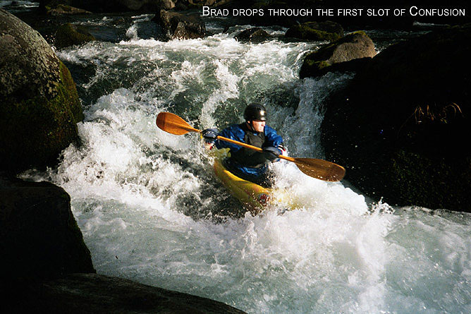
Below this slot I usually grab the eddy on the left and then work around the left side of the next boulder fence and then head back to the right. From here I generally head towards the center of the river and eddy hop my way down. 'Confusion' lasts about 200 yards!
On this particular day Brad ended up in a pin somewhere over on the left side of the river, and when I didn't pay enough attention on the second lap, I ended up in a pin in the center. I had to hop out of my Rockit and onto the rocks to get my situation straightened out. It pays, when creeking, to have a boat with a cockpit that's a snap to climb out of! Watch out for shallow rocks in the last drop of 'Confusion'. Take the obvious center slot, but boof hard with left angle or you might piton. 'Confusion' ends with a large eddy on river left.
Two drops lead into 'Shark's Tooth'. I usually find this to be the meanest rapid on the Mile when the flows are low. The crux move is very, very tight! Eddy out in the middle of the river (one or two boats will fit), and look for a boulder in midstream about 12 yards downstream. Exit that eddy through a narrow slot on the right and then head straight for a narrow 1.5-foot wide spot just right of the big boulder. If you hit the mark, you'll squeeze through! At flows a bit below 6 inches this slot becomes too narrow, and I usually opt for a sketchy airplane turn to the right just above it; if you blow the turn, you're pinned. At higher flows you can boof that big boulder. This drop has a long run-out before the next big eddy on the left; hang on for the ride!
When you exit that last big eddy, you're heading into the gut of 'Whoop-de-do'. You'll recognize the rapid by an island (stay left), and some big logs on the bottom left (don't go under them). As you head towards the logs, you'll boof over two consecutive 3-4 foot boulder-ledges. After the second drop head right, and preferably catch the small eddy above the last 8-foot drop on the right (up against the island) or the small eddy in midstream. There are two good ways to run this final drop: the Boof, or the S-Turn. If you angle too far left off the boof you'll end up stuck like Brad! To his credit, he got out of this pin without help and without getting out of his boat!!
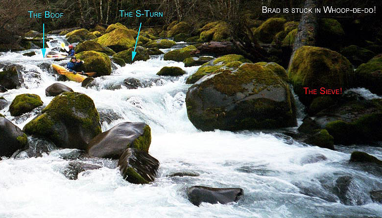
I usually choose the S-Turn at this low flow, but I ALWAYS opt for the boof at higher flows. If you opt for the S-Turn and don't make the hard right turn around the boulder Brad is leaning against, you'll probably flush into the boulder and log sieve on the left. At really high flows I suggest hugging the island on the far right bank.
Below 'Whoop-de-do' the drops get smaller, but they're also more frequent. The first will entice you into an eddy on the right (Mike is heading for it in the photo below).
Unfortunately, once there you must ferry back to midstream across a fast jet and then take a midstream slot that is obscured behind the large midstream boulder in the photo. Everywhere else the water sort of sieves out through the boulders. At high flows this ferry is a bit stressful! Mike & Brad had some fun in this one. Both ended up on far river left (not where you want to be) and banged down through the boulder jumble over there. Mike evidently flipped and for one scary moment he felt his head lodged between a couple rocks!
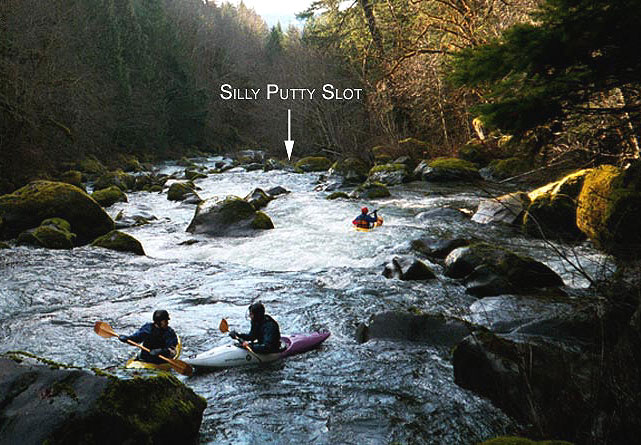
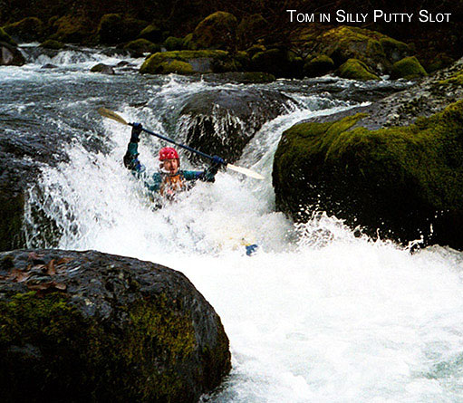
The next eddy on the right is just above what Jason calls the 'Silly-Putty Slot'; so named because if there was a log in there you'd wrap around it like Silly-Putty! I'd have someone scout this blind drop from shore the first time down.
Don't relax once you're below this slot. Even though the individual drops don't measure much more than 3-5 feet, the gradient is still around 240 fpm and the nondescript rapids just keep coming at you for another quarter mile. Eddy hop your way down and pick your own routes. Do watch out for a very bad log on the left and center in a couple hundred yards. At low flows you won't be lured into it, but it starts to get covered around a foot. Some people have had some pretty desperate pins here when the water is pumping! If in doubt, stay right!
After this last quarter mile you will come to a 3-4 foot drop on the right just above where Christy Creek comes in and within sight of the take-out bridge. At higher flows its pretty easy to boof this guy on the right and then catch an eddy in the Christy Creek confluence prior to heading on downstream to the bridge. However at flows below 8 inches there are nasty piton rocks below the two obvious boof lines on either side of a midstream boulder. I have had many perfect boofs over these hidden rocks, but on a solo trip after these photos were taken, I minutely blew my boof, pitoned, and promptly rotated into an upside-down 45-degree vertical pin! I know several others who have vertical pinned here in a similar fashion. Since the water was low, it was pretty trivial to fall out of the boat while hanging onto all my gear. And I was also able to CAREFULLY wade along the underwater boulders until I found a boulder big enough to allow me to empty and climb back into my boat. At higher flows this would have been a real mess! On my second trip I bashed my way down through the shallow, but non-vertical rock slide up against the right bank. I recommend this line if you want to be certain of avoiding any potential embarrassment from a vertical piton/pin.
Finally look for a SWEET boof off a midstream flake just above the bridge! But remember this turns into a huge hole at high flows; actually the whole run turns into huge holes. Take out on the left above the bridge and carry up to your car for the second, third, or umpteenth lap.
If you choose to continue past the Christy Creek bridge watch out for the very next rapid. It's a technical, steep boulder slalom to a moving eddy just above 'DragonSlayer'. This is a class IV ledge drop that has an EXTREMELY retentive hole (at flows around 6 inches to a foot) in a slot on the right side. This hole would be difficult to get a rope into since it's against a 40-foot vertical wall, and the left shore is about 30 feet away. Be careful on this one; its been known to pin people to the bottom of the riverbed and rip their booties right off their feet! Most folks either choose to take out at the Christy Creek bridge, or sneak this drop through the scrapy boulder garden on river left.
-Steve Stuckmeyer