
Since the beginning of time, mankind has wrestled with a profoundly complex and apparently unfathomable mystery....
'Is it the North Fork or the West Fork of the Washougal?.'
Nations have toppled, space has been conquered, and yet this one, nagging mystery remains open to question to this very day. Several institutes have been formed and top government officials refused to be interviewed on this sensitive subject for this report: they cited national security and then tried to apprehend me when I asked about it and I have been on the run ever since!
You cross two bridges on the way to the put in- one says West Fork and the other says North Fork. As if that weren't bad enough, half the guidebooks call it the North Fork and the others call it the West Fork. I was unable to unravel this epic debate so I decided to take the middle ground and call it the Northwest Fork. I shudder at the controversy this is sure to ignite... =)
With two key portages, I found this run definitely worth doing and worth returning to. The river is very scenic and the upper sections have a remote, creeky feel to them. If I lived closer I would certainly run this section more often. It should be noted that I didn't take many pictures the day we ran this section because we were moving pretty quickly so most of the photos are of the portages. I am a little concerned that this gives the impression that the NW Fork is all portages and no whitewater, but that couldn't be further from the truth! There are some very high quality class III, IV and one (portagable) class V rapid that are very clean and definitely worth experiencing!
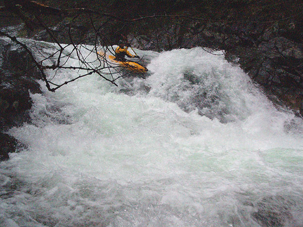
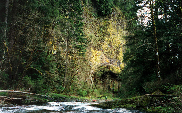
This river used to have a lot of wood on it but recent floods have cleaned it up nicely. We had one easy portage around a tree that had fallen into the river very recently, but there really wasn't any wood in dangerous spots on the rest of the river. Below the put in this river has a small, creeky feel with lots of small twisty drops in a really intimate little gorge. I was immediately impressed with the scenery as we eddy hopped down through this fun upper section. Within a half mile the river disappears over 16 foot Teakettle Falls, boof left on the second drop as the water pours into a hole backed by a boulder on the right.
Pete Giordano probes Teakettle Falls. All of the water pours on to a boulder on the right forming a large, backed-up hole, so you have to drive left in order to avoid a piton-beatdown..
The next drop marks the beginning of a series of bedrock formations that form narrow, powerful rapids that must be scouted for wood.
Downstream are more narrow, ledgy drops that would probably fill in a bit at higher flows but at med-low flows required scouting and consideration.
John Whaley runs a narrow drop.
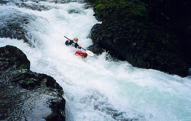
Next up is a double falls, the second drop of which that exits through a very narrow, violent slot. Jesse Coombs fired this one off the last time we ran it. The portage is on the left and requires a seal launch.
Jesse Coombs finishes scouting the double falls, which he ran without problems. The first drop is easy, but the second drop is very violent and about seven feet wide. It would be easy to get wedged if you were off line.
Below the double falls the river drops through some small gorges and three or four more clean bedrock chutes. I found the geology of this river to be quite interesting. It never really solidified enough to form the kind of classic waterfalls that dot the nearby White Salmon or the Little White, but it still has some nice rapids mixed with what I would consider to be two mandatory portages.
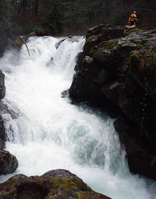
The second (very easy) portage is marked by a definite horizon line and a totally unexpected house perched on the wall of the gorge two hundred yards directly downstream, with an obvious horizon line. Get out on the left and ponder the horrible undercuts (the river actually flows left to right under the wall after the initial plunge!) then portage and seal launch on the left.
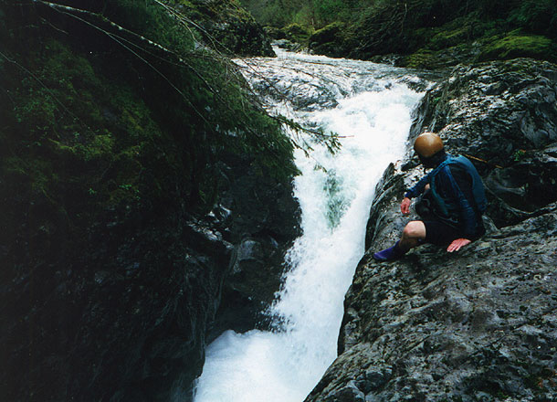
John Whaley ponders the horrible undercuts below the last falls..
Below the slot falls are some more fun gorgy drops alternating with some mellow class II floating. The next large bedrock rapid is marked by this striking cliff wall- eddy out on the left to scout. This drop can be run down the far left at medium to high flows, or boofed off the middle at medium water.
John scouts the cliff drop.
The last big drop is marked by a house on the left and a small runnable weir. Below here is a second small ledge and then a big, narrow chute. We ran the slide down the far left here. Below this drop the river is mellow all the way to the confluence.
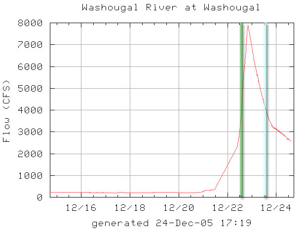
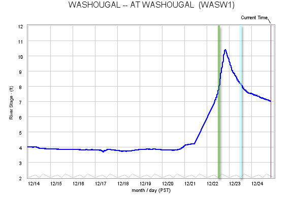
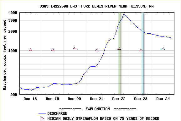
The photos with Pete and Jesse (Teakettle Falls and the Double Falls) were taken at a good (optimal) medium flow, see graphs below, the green and blue bars. The photos with John Whaley were taken at a low flow, I don't remember what the flow was that day, but it was too low.
You need a big rainstorm for this one to run; it does not get any meaningful snowmelt event in the spring.
See below for the graphs for good medium flows on this section. We ran this section on both days shown below, the green bars in the graphs below felt medium-high. The blue bars in the graphs below felt medium, that was the day I took the photos of Jesse and Pete.
Washougal cfs gauge. Between 4000 - 5000 cfs is the optimal flow, either rising or falling.
Washougal foot gauge. Between eight and nine feet is the optimal flow, either rising or falling.
The old standby gauge, EF Lewis. We used to use this before the Washougal gauge came online.
Not sure how well this correlates, but you want between 2000-3000 cfs.
Access: The Bennett Guide has good shuttle directions with one small exception: about halfway to the put in the road turns to gravel. Everything else is correct.