The Owyhee River
"Widowmaker Section"
By Steve Stuckmeyer

Copyright © 2001, Oregon Kayaking. No part of this page may be reproduced, linked, or copied without the express written permission of the author and the Oregon Kayaking Webmaster.
By Steve Stuckmeyer
The Owyhee River
"Widowmaker Section"
Copyright © 2001, Oregon Kayaking.
No part of this page may be reproduced, linked, or copied without the
express written
permission of the author and the Oregon Kayaking Webmaster.
We had grand plans for the Spring Break of 2001. Scott Reed had put together a trip through the University of Oregon's Outdoor Program and we were headed for the Upper and Middle portions of the Owyhee River in Southeastern Oregon. Our goal was to float 87 miles, starting on the South Fork Owyhee in Nevada, traveling into Idaho, and finishing at Rome, Oregon; all in the span of 5 river nights. Our complement of boaters would include 3 kayakers, 6 rafters, and one open canoeist. And as is often the case with grandiose plans, we hit several snags before finally reaching the end of the trip.
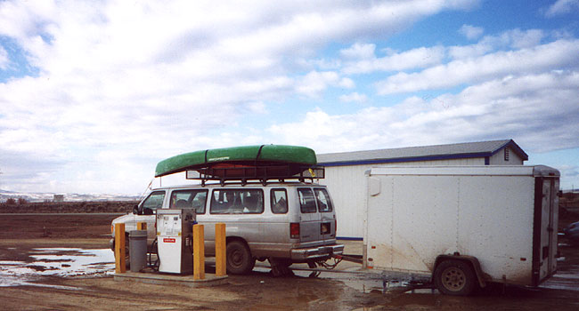
Friday night, March 23, we all packed the van and trailer at the OP Equipment Barn. We met again early Saturday morning and by 6:30am we were on the road heading east from Eugene. After about 8 hours of nearly non-stop driving, we arrived at the home of our shuttle coordinator (Eva Easterday) just outside of Rome. She told us we could pick up our shuttle driver (Marvin) at the rodeo up the road in Jordan Valley. Marvin would ride with us to the put-in in Nevada, camp out with us, and then bring the van and trailer back to Rome. Marvin was a semi-retired fellow who had lived out most of his life in this extreme southeastern corner of Oregon. His quiet sense of humor proved invaluable on the remaining bit of our long shuttle. We left Jordan Valley around 3pm; we still had an estimated 6-8 hours to the put-in! Our route curved north to the Snake River, ran along the snake to Grand View, and then headed south to the Duck Valley Indian Reservation.
The van, after our little nocturnal adventure...
We finally left the highway at Duck Valley several hours after night had fallen. Our trip was just about to get very interesting since we had minimalistic maps of the gravel and dirt roads, and only Marvin had ever been in the area and I think his knowledge was many years old. At first the one-lane gravel road seemed OK. It had areas of deep ruts and a few wet spots, but was generally good enough to allow us to average about 15 miles per hour. An hour after we had started on this road, and after several questionable turns, we pulled to a stop outside a brightly-lit natural gas pumping station. It sounded like a jet engine running in the desert wilderness.
We were lost.
After consulting all of our maps (primarily the 1955 topographic and Marvin's hand-drawn version) and taking rough measurements from Scott's GPS device, we concluded we had taken a wrong turn about 8 miles back and were now just above the canyon rim of the East Fork Owyhee at Garret Crossing. We backtracked and of course found a plainly marked sign at a Y in the road; it pointed EF the way we had come, and SF the other way. I guess it's hard to read signs by two dim headlights in strange territory. Scott turned onto the road headed for the South Fork, and those of us with the maps and the GPS started to follow our course very closely. In another half an hour we turned onto a two-track trail, and about 2 miles and 20 minutes later we turned onto another two-track trail; this one was dirt. We were obviously on the right course (from the maps, the GPS, and the fact the sagebrush had been mowed from the center of the two tracks). Unfortunately the dirt tracks started to get muddy in places and the GPS said we were still about 25 miles from the put-in we wanted. Our somewhat insane crew of boaters decided to push onward into the unknown. We would cheer Scott onward as he would gun the van through the rutted muddy spots in the trail; we were feeding off of one another. Finally one particularly bad spot, where the van tilted significantly as we raced through a deep mudhole, started to flash warning lights in my head; I and another passenger voiced our thoughts that we were about to get ourselves into a really bad situation. We were 20 miles from the nearest village on the reservation and we were attempting a slimy trail in a 2WD van pulling a heavy trailer; I didn't like our odds of ever making it through that remaining 20 miles. It seemed every quarter mile further we were halving our odds of ever getting there, and with even worse odds of ever getting the van out again.
We stopped and discussed our options. At first it seemed like there was significant resistance to admitting defeat, but it gradually dawned on everyone how precarious our situation had actually become. We decided to turn around. We weren't even sure we could get back out. We put the snow chains on the tires to give us some more traction and then Scott pulled a U-turn through the sagebrush. The way out was even more exciting than the way in had been. The muddy spots were now quite churned up and deeper than before. At the worst one I thought we were going to tip onto our side when the wheels dug into the deep ruts; it was close. After a tense half-hour struggle we had made it back onto the lightly graveled road and called it a night. At about 1am we finally settled into our tents among the sagebrush.
Sunday morning we woke up and decided upon what was really our only viable option; we had to backtrack all the way back to Jordan Valley. From there we could drive up a fairly decent road and into Three Forks on the Main Owyhee. This would have been the halfway point had we started our trip on the South Fork of the Owyhee. The remainder of the drive went smoothly, and after spending 24+ hours driving, we had finally reached our put-in. Around 2pm, we waved good-bye as Marvin drove the empty van and trailer up the switchbacks and disappeared over the canyon rim.
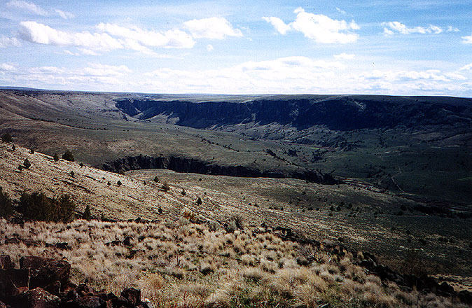
Three Forks on the Main Owyhee from Canyon rim, deep in the Oregon High Desert.
Sunday afternoon and evening was a leisurely time, as we set up camp and cooked dinner. The Three Forks put-in is a beautiful setting; the canyon walls are nearly sheer as 3 large canyons converge and then exit through a vertical-walled notch. When dinner was completed some of the group decided to call it an early night, but most of the group decided to ferry across the river and hike about 2 miles upstream to where we thought a hot spring was located. Darkness fell shortly after we crossed the river. I was at the front of the group as we cut cross-country through juniper and sagebrush; it wasn't long before I had outdistanced the group. I knew there would be a road if I just contoured around a large volcanic plug, and I found it in short order. I hiked along the road in the dark until I reached an intersection. I decided to wait there and make sure everyone else took the right turn. After 15 minutes, I still had not seen any sign of the rest of the group and began to wonder if they had turned back. I was almost on the verge of going back 15 minutes later, when I suddenly saw lights high on the mountainside above me. Evidently, rather than contouring around the plug, the rest of the group had climbed up it. So I continued uphill on the road until I reached the saddle. Once there I signaled to the group that they needed to descend to the road and sat down to wait.
When we had all regrouped, we headed downhill on the old road. It didn't look like it had received any use since the previous summer. I soon outdistanced the group once more, and arrived at the location of the springs first. I found several small hot springs, but could not find the large swimmable pools that were supposed to be there. The river was fairly high so I eventually assumed they had been flooded out. (Later I learned the best hot springs were on the opposite side of the river). After I completed my search, I climbed up on a large rock outcropping and amused myself with the many pinpoints of light as the remaining members of the group hiked about in search of the springs. We obviously never found the correct hot springs, and were soon hiking back through the night to the campsite. I was very happy when I successfully ferried my kayak back to the other side of the river. Crossing a swollen river at night, with no sprayskirt, and with the light of my lone headlamp, was not my idea of fun. In fact it had me very, very nervous, especially when I shipped about a cup of water when I was caught off-guard by a little eddy line at the start of the ferry.
Monday we awoke to a frosty morning, but the sun quickly warmed up our blood. We were pretty unhurried as we cooked breakfast and then packed our camp into the rafts. I think it was about noon when we finally floated downstream from Three Forks. The first mile and a half of flatwater led up to The Ledge. We all got out on the left and scrambled downstream to have a look at this long class IV to IV+ boulder garden. There was a swift class II+ entry to a 6 foot ledge and then a series of narrow routes between huge boulders for the next 300 yards. A broken raft frame on the left boulder bar attested to the fact that many rafts never make it past this rapid. I stopped scouting after the first drop and headed back upstream to lead through the rapid with my kayak. The route I picked over the first ledge was a no-brainer and allowed me to eddy out, climb back on shore, and take photos of Bob, Lyle, and Jim as they ran that first drop.
I then climbed back into my kayak and ran down to the river right bank about halfway through the rapid. This gave me an excellent vantage point to get photos of the rafts running the center drop of the ledge. I could also easily see the remainder of the rapid dumping into the big pool downstream. While I watched, Jim decided to finish off the rapid. He was looking good, but was stopped and side-surfed by a large hole at the bottom of the rapid. He flipped, flushed out of the hole, but was unable to roll his open canoe. He swam and several whistles started to blow. I watched carefully, saw he was swimming strongly into a large eddy with all of his gear, and gave the all clear signal to those of our group who were upstream. Scott was about to bring the large Sotar gear raft through, and he had no problems at all. In fact it was a near picture-perfect run. After Scott's run, I hiked downstream a bit and waited with my camera and throwbag on a rock outcropping next to the hole that had surfed Jim. I took a couple of photos as Lyle ran through the hole in his kayak.
Scott dropping over The Ledge
The next raft to come down was piloted by Brad. I don't think Brad had much experience rowing a heavy boat through class IV whitewater prior to this trip, and he certainly learned a lot by the end. He had no problems through the first half of the rapid, but was unable to pull away from a wrap rock about 25 yards upstream of my location. His boat hit the rock sideways and was instantly flipped sideways into a pin. His passenger, Suzy, was flushed under the raft, dropped into a hole just downstream where she was recirculated a bit, and then flushed downstream where she was able to grab a throwrope from one of our safety people. Meanwhile I was not able to see Brad, and started running upstream to be even with the raft. I was worried he might be caught up in the rigging or the raft frame. Then, just as I started running, I saw Brad climb out onto the end of the raft. Once there he held onto the grab loop with both hands (his body was hydroplaning) and used this leverage to pull the raft off the rock. He saved us hours worth of work with his quick thinking.
Pinned in the runout from The Ledge
It was pretty evident that Brad, Suzy, and the raft were going to be OK, but there was miscellaneous gear floating quickly downriver and no one was in the water to chase it. I ran upstream to my kayak, while Lyle ran downstream to his. We were both off to the races chasing 2 oars, 2 paddles, a throwbag, and a little plastic duck. After about half a mile, we caught up with most of the equipment. I snagged the throwbag and towed an oar to shore, while Lyle grabbed the two paddles. Lyle climbed out and pulled everything onto shore, and I started heading further downstream in case the other oar had floated further down. Along the way I found the little yellow duck. I continued about another half-mile before deciding the other oar must have been shoved under some rock and lost for good. I took out on a sunny sand bar and waited for the rest of the group to catch up.
After 15-20 minutes of lying in the sun I was warm, and bored, and decided to walk around a bit. I headed upstream and stumbled across a hot spring with two man-made pools large enough to lie down in. I also noticed this was the location of an old homestead and would make a nice camp, so I carried my boat and gear upstream to a prominent place at the head of an eddy and undressed down to my swimsuit. I then took my paddle and hiked back down to the hot spring. I shoved my paddle into the ground as a signpost, and then slipped into the warm water. It was heaven! Waiting in a sunny pool of water about 108 degrees Farenheit; I couldn't believe my good luck! About half an hour later, the rest of the crew showed up, saw my boat and gear, and eventually saw me soaking in the hot spring. Lyle couldn't get over his bad luck, when he realized he'd been waiting just as long in the shaded canyon upstream; he had evidently become quite cold by the time the rafts finally caught up with him.
Even though we had only traveled about 3 miles, it was already almost 4pm and we decided to make this lovely spot our campsite. It turned out to be the most pleasant place we camped. You can't do much better than having a naturally hot bathtub within 25 yards of your tent. It got very windy that night, so we couldn't make a fire, but we did have an excellent Falafel dinner cooked by Ed and Tina.
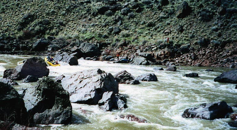
The next morning I awoke, had my daily dose of coffee, and then headed for a quick soak in the hot spring. About 10 minutes was sufficient to warm me up and get me ready to pack up my tent and dress for the river. I think we finally left the campsite at 10am. We had a long way to float; our goal was a campsite at Soldier Creek fourteen miles downstream. The first 5 miles was a class II float past the Deary Pasture (an area where the canyon is wide enough to allow cattle to graze close to the river). The whitewater was tame, but the scenery made it very worthwhile. Around 12:30 we arrived at the top of a steeper class III rapid that looked like it was headed towards the base of an earthen dam. This was the landmark that signaled Half-Mile Rapids. We ran the lead-in class III, eddied out next to the boulder bar on river left, and sat down to a quick lunch. Afterwards we scrambled our way downstream through and over the large boulders and scouted Half-Mile as it curved to the left. I just picked my line through the first 200 yard drop, chose an eddy to get out in on river right, and then headed back for my kayak. Almost everyone else continued to hike downstream to see the length of the rapid.
My line through the first part of Half-Mile went well, but I was caught off-guard by a lateral wave at the bottom of the segment and ended up getting flipped. A quick roll put me back in control, and I was soon clambering up the steep boulder wall that formed the right bank of Half-Mile Rapid. After I had gotten about 100 vertical feet above the river, I had excellent views of the entire rapid. The crux of the rapid was obviously the last part several hundred yards downstream from my position. Most of the river crashed into a series of huge boulders along the right bank; safe passage was only found on the left side of the river. After I had taken photos of Lyle running the rapid, and Jim lining his canoe along the left bank, I climbed back down to my kayak and waited for Scott to run the first segment.
Upper Half-Mile Rapid (Jim is lining his green canoe)
As usual, Scott had no problems and subsequently caught the relatively small eddy next to my position on the right bank. After a brief rest, during which I climbed back into my kayak, we proceeded into the final stretch of Half-Mile Rapid. I followed Scott from a safe distance, and we both rode through the rapid with no mishaps. Just below the steepest section, I powered over to the right bank and climbed out with my throwrope and my camera. I climbed along the large boulders to a vantage point a few yards below the most dangerous part of the rapid and sat down to wait for the next raft.
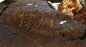
While I waited, I was looking around and was astonished to see that I had just happened to sit down next to a large boulder covered with petroglyphs! With my memory jogged, I remembered reading a trip report that described these very same petroglyphs, but I entirely forgotten about them during the long scout of the rapid. They were located on a boulder near the edge of the river and you could see that high water had slowly been erasing the hard work of the human hand. Needless to say, I took several photos of these ancient carvings. (Note the fish on the right).
Petroglyphs (indicated by the arrow)
|
|
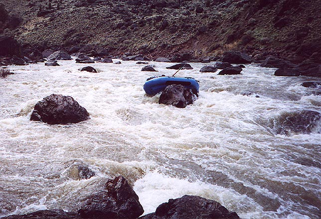
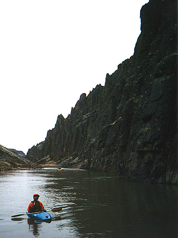
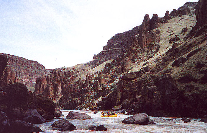
Immediately below Half-Mile Rapids is Raft Flip Drop. This 5 foot ledge forms a river wide horizon line. I had briefly seen it from far away and high above, so I wasn't too worried about it. I probed by running along the left bank, trying to stay out of the main current. This was a mistake since I saw the middle of the drop was just a large roller, while the left was a vertical plunge into a wicked hole. I boofed very hard and avoided getting worked. I then signaled everyone else to ride it down the center. It had taken us a long time to make our way through this 3/4 mile section of river! Our goal, Soldier Creek Camp, was a long 6 miles downriver. Fortunately this section of river was fairly mellow with many class II's and long gorgeous flat stretches with vertical walls often coming straight out of the water.
Bob on one of the flat stretches
It wasn't too long before we ran through a longer class III rapid, and then caught and eddy on the left bank to scout Bombshelter Drop. This was really not much more than a III+, but it did have a couple required moves away from a headwall at the top and around some wrap rocks and holes at the bottom. After a quick glance I headed back to my kayak and probed the rapid. It was a piece of cake, and in moments I had climbed back out of my kayak and up to a photo vantage point on the right bank.
During Ed and Tina's run, Ed didn't pull away from the headwall strongly enough and sort of bounced the nose of the raft off of it. This didn't look like much of a problem, but the impact was enough that it launched the dog (Tilly) and Tina into the river. While Ed tried to get the boat straightened back out and away from the wrap rocks just below, Tina and Tilly were struggling for shore. Immediately it became apparent that they were in serious trouble. Neither were able to make it to shore before being swept into a line of boulders guarding the lower left side of the rapid. My heart was in my throat as I watched Tina careen through the many entrapment hazards, and I breathed a huge sigh of relief when I saw her surface in the pool below the drop and climb onto the boulders. But she let out an anguished scream, and I realized Tilly was nowhere to be seen! I scrambled upstream to get a better view of the area, and Tina did the same on the left bank. Where was the dog?!? We all feared the worst, when suddenly Tina saw Tilly. She had crawled into a tiny nook on the left bank that was formed by two huge boulders. She was momentarily safe, but trapped and very afraid. I snapped a photo of Tilly's predicament as Ed swam around the boulder (on a belay) and helped Tilly back upstream to safety.
Ed about to rescue Tilly; if you look closely you can see Tillys yellow PFD in the dark triangle formed by the boulders.
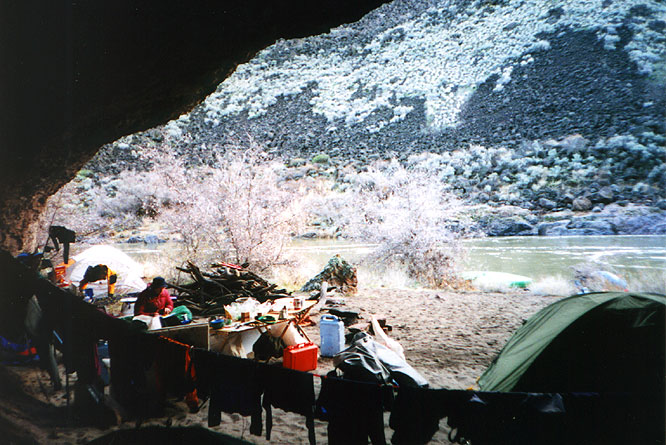
This series of events burned up to an hour of daylight, and by the time we got the final boats through the rapid we were down to about an hour of full light. We really had no choice but to camp just downstream in Bombshelter Cave. The cave is an excellent shelter with at least 30x30 feet of covered space. It is below the high water mark, but at 2000 cfs we were still about 10 feet above the river. When it started to rain just after dark we were very happy to have stopped at the cave. There was a large stack of dry firewood, so sitting around the fire next to our kitchen was a wonderful way to spend the evening. It showered much of the night.
Camping in Bombshelter Cave
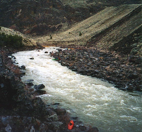
We tried to get an early start the following morning. This was the day we had to deal with Widowmaker and we were starting 4 miles further upstream than we had planned. After a mile of easy water, the first rapid was the Shark's Teeth. A line of boulders cluttered up the entire river with very narrow slots between them. The only runnable route, for rafts, was so narrow that they had to tuck their oars. It was a straightforward drop, but had a tricky current leading into the narrow slot. It got the better of Brad's raft and he broached on a boulder at the top. At first it looked like it would turn serious, but fortunately they slid off the boulder and pinballed down a tight flume just to the left of the intended route. Brad had a few choice words to say after that experience!
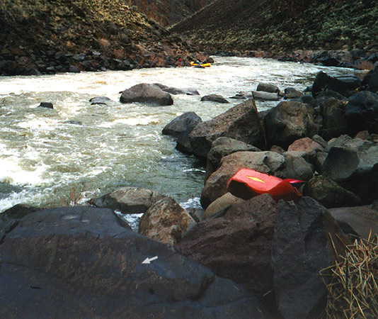
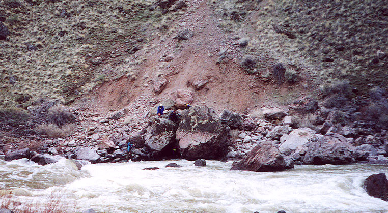
We passed Soldier Creek around noon. After this wide, lazy area, the river started to narrow and steepen as it headed towards the Widowmaker. After a few steep class III wavetrains, I recognized the lead-in to Widowmaker (I had seen it in a photograph) and pulled out in a large eddy at the top. A quick hike to the top of some large boulders confirmed my suspicion. A 200 yard class III-IV rapid dropped and narrowed directly into Widowmaker. There was a small eddy directly above the Widowmaker that we would need to move into next, but it was a hard entry with a large eddyline. Unfortunately we did not have any rafters who planned to run the main drop, so moving downstream to this final eddy was necessary. If we did not, the portage length tripled and became infinitely more difficult. Widowmaker itself was a massive 10 to 12 foot drop with 2000+ cfs roiling through a channel about 70 feet wide. There was a runnable line, but the rapid was a V+, and we were in the bottom of a nearly inescapable canyon and at least 20 miles from the nearest highway. It wasn't worth risking our gear or our lives. We all portaged.
Portaging Widowmaker was an epic undertaking. It was only about 50 yards long, but it was over and through huge boulders. A lifejacket and helmet were pretty much required safety items in the event of a fall, and broken bones could have easily resulted anyway. We had to strip every item of gear from the rafts, including the oar frames, carry them individually and then reassemble the boat in a one boat launch site just below the big drop. But the first order of business was to get all the boats down to that final eddy.
Scott rowing the lead-in to Widowmaker
As the boats would come downstream, the oarsman would pull heavily into the eddy, and the passenger would throw a secured line to shore where several people would grab it and then secure it into a belay device attached to my quick release tether on my rescue PFD. I was tethered to a massive boulder by another short length of rope. It was a last-ditch setup designed to prevent a raft from floating into the worst part of Widowmaker if the oarsman wasn't able to pull into the eddy.
The first two rafts came down without any problems, although when Scott's raft at first appeared to be laboring toward the eddy, Bob got a little anxious and threw the line to shore prematurely. It landed about 10 feet short of the shore! Fortunately Scott slowly managed to row the heavy Sotar Pro out of the current and into that eddy. The last raft was Brad's, with Scott as the passenger. On the final approach, the raft came too close to a boulder, hit it, and bounced back into the main current. Even with Scott helping to paddle, they weren't making it out of the main current! Scott threw the first rope. It barely reached shore and bounced back into the river. Lyle jumped in to grab it. Scott threw the second rope and it made it to shore with enough spare length to get it to my position where I quickly cinched it into my belay device. The raft did miss the eddy, but with the two lines we were able to quickly reel it in towards the right bank and pulled it onto the rocks about 15 feet below the eddy and about 15 feet above the first drop of Widowmaker! I hate to think what Scott and Brad must have been thinking as they were being inexorably pulled into the Widowmaker. About 4 hours, and 50 yards later we completed the portage!
Putting in below Widowmaker
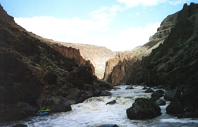
Below Widowmaker, the river flows through one of the most spectacular canyons I have ever seen. For miles the walls rise straight out of the water for perhaps a thousand feet. The river is actually pretty mellow with flatwater pools alternating between class II rapids and riffles. After the long arduous portage we were all tired. Unfortunately the temperature had dropped, the wind was picking up, and this section of canyon has very few camping spots. Finally, about 2-3 miles below Widowmaker, we found a small sandy bench about 40 feet above the river that had just enough flat space for all of our tents. In spite of the climb, we chose to camp here and we were very pleased to find a large nook behind a rock outcropping that would shelter our kitchen from the stiff breeze.
Darkness fell about 45 minutes after we had pitched camp, so dinner was prepared and eaten with the use of our headlamps and the camp lantern. The wind kept up and eventually culminated in a rain shower. This cut short our evening gathering and scattered everyone but the cleanup crew into the tents.
Our final morning on the river was much the same as all the others had been. Cold and crisp. We had breakfast and packed up camp quickly. After the first couple of very scenic miles in the narrow canyon, the walls started to peel back and we stopped to have lunch at a small side canyon coming in from the left. This was Sand Gulch. We had left the inner canyons of the Owyhee and had arrived at the outskirts of civilization and ranch country. About a mile or two below this lunch stop, the final remnants of the vertical canyon walls ended at a rapid formed by the remains of an old dam that had been blown up; the last several miles to Rome consisted of the river meandering slowly between steep mud banks.