
Roaring River is a fairly steep (~200 fpm) tributary of the Clackamas River that joins the Clack at Roaring River rapids. This river flows through the Salmon-Huckleberry Wilderness and is quite scenic and challenging. I had always wondered about this stretch, and when I read Dan Coyle's trip report on the section last year my interest was heightened. Dan described steep drops with some good IV+ to V- technical whitewater and geology that made the river prone to big hydraulics. Given the caliber of boaters on that trip (and the fact that there was one nasty swim) Pete and I knew that the Roaring would provide a nice challenge.
We had done some map reconnaissance and determined that the access to the Upper Roaring was quite limited as most of the river flowed through a deep rocky canyon. The long hike to the put in that Dan described was one of the only access points for several miles. We found a trail on the map four miles or so upstream and were determined to put in at this higher point and see what the Upper Roaring had to offer.
Our trip started off a bit slowly to say the least. Pete and I headed out on a warm and sunny spring day with high hopes for exploring a new river. Dan had described the lower three miles but we wanted to put in a few miles higher so we kept on driving up the gravel road until we hit snow. Now, we never let a little thing like snow get in the way of paddling, so we grabbed our gear and headed out.
Pete begins the long slog up the mountain.
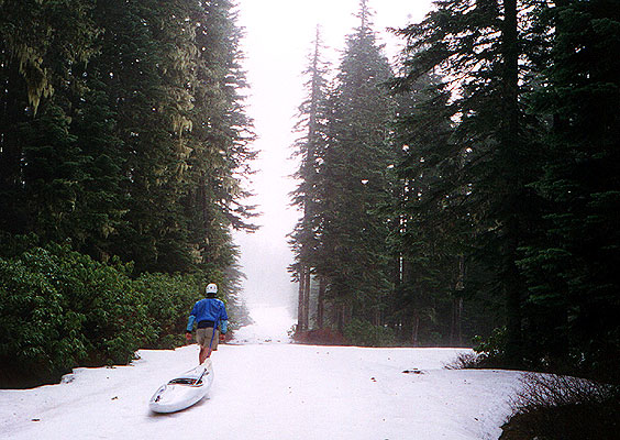
After a couple of hours of dragging our boats through the ever deepening snow drifts we arrived at where we thought the trail might be leading down to the river. We looked around for Plaza Creek, which was supposed to parallel the trail down to the river but we couldn't find it. The biggest problem was that the snow drifts were five to six feet high and packed solid by repeated melting cycles. The river was two more miles away and the prospect of postholing our way down through deep snow with no trail didn't appeal to us very much. Nevertheless, we were determined to find an alternate approach. We dragged our boats back down the road and tried to follow Squaw Creek down into the canyon but it pretty much dropped off the face of the earth shortly after we got into the woodline. This was getting a little ridiculous, especially now that I was running out of water and Pete was getting ready to throw me off the cliff for leading him on a wild goose chase. Reluctantly we started back to the truck in the now oppressive afternoon heat, which was made worse by the reflection from the snow. I have never had to protect against snow blindness while kayaking, but there is a first time for everything! I was a little unprepared for this eventuality so I cobbled together a makeshift baklava out of my highly aromatic polypro bottoms to protect my skin and eyes from the blazing sun.
By the time we got back to the truck we had been hiking a total of six hours and I was out of water and ravenously thirsty. Pete promptly drank a beer but since I don't drink alcohol I had to settle (so to speak) for the water that had pooled in the bottom of the cooler. Refreshed, I began the considerable task of convincing Pete that we just had to paddle today and that the lower Roaring was worth doing. Soon we found ourselves bouncing down the poorly maintained road to the put in for the lower section that Dan had described. Eventually the road ended with a huge pool of muddy water beyond which three smaller four wheel drive roads took off in every direction. "We'd better find the trail quick, because if I drink another beer I won't be paddling anywhere today," Pete said firmly. Motivated by the prospect of running the lower section, I took off down the trail at a full sprint. I ran about a hundred yards down a ever deteriorating road and then tripped and took a header into a big muddy pool of water, cutting my hand and knee in the process. "Good thing there wasn't any glass." I thought as I brushed myself off and continued down the road undeterred.
Soon I found the trail, and when I arrived back at the truck Pete was already getting his stuff together. We headed down the trail and forty five minutes later we arrived at the river. It was now four p.m. and we had been going non-stop since eight am that morning. We were tired, bruised, and footsore but no river had ever looked so good! In retrospect we should have been extra careful because our level of fatigue was bound to slow our reflexes, but we didn't really think about it at the time...
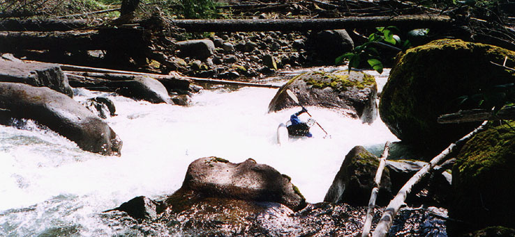
We wasted no time getting in the water and were soon enjoying a few small warm up rapids. Soon the river rounded a corner and dropped out of sight and we got out to scout. "Oh s--t." I grumbled as I saw what looked like an enormous logjam just downstream. When we got a little closer we found the remains of a log jam rivaling the monster jam on the Upper Collowash, but here the river had punched a clear channel down the middle of it. There were a few logs at the top blocking the river and they required a portage on the far side of the river. Pete ran the first rapid and got blown off line in a big hole, flipped, and got flushed upside down through a narrow slot. I ran downstream past the slot in time to see him emerge on the other side and roll up, shaking his head. I could see that something was wrong and when he got to shore he said he had hit his face hard on the rocks just below the slot. His ear was cut and there was a red spot on his cheekbone that would balloon into an admirable lump by the end of the day!
Pete about to take a big hit in the first rapid.
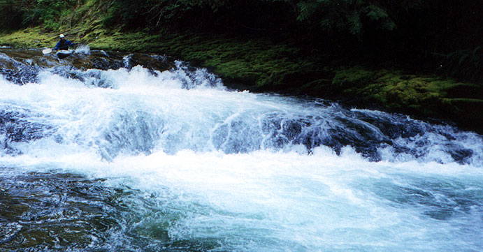
Downstream we found some excellent large boulder gardens that made it all seem worthwhile. There was also a fair amount of wood to watch out for. (we had to portage a total of five logs in three miles). The river tumbled right along with continuous rapids but we were being cautious because we knew there was a rapid with a hole that had thrashed one of Dan's crew so bad he was puking water by the time he swam out of it. Soon the river narrowed and we could see three clean horizon lines downstream from the eddy above. I got out to scout and soon determined that the bottom hole on this triple ledge drop looked like 'the one' so Pete ran it while I stood by with a rope. There is a small hole just above the final drop that slowed Pete down enough so that when he dropped into the bottom hole he had to work like crazy to get out of it. I went next, and managed a marginal boof in order to avoid the meat of the bottom hole. When I cleared it I remember looking over at Pete and grinning smugly as if to say "Not bad, eh?" Just as I did this I noticed a strange pulling sensation- I had underestimated the considerable size of the hole's recycle and I had to paddle frantically to escape, much to Pete's amusement...
Pete runs the first part of the ledgy triple drop that has 'The Hole' at the bottom. The mean hole isn't pictured here but is just out of sight downstream.
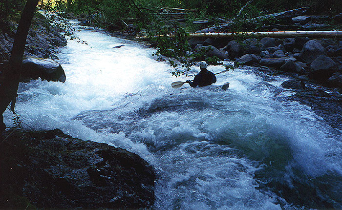
Soon we encountered more wood and as I watched from an eddy above Pete ran a steep drop on the left, boofing hard to avoid some logs on the right. I came down next realized a moment too late that Pete had boofed a big stump and that he was actually signaling me away from the stump... Too late I saw my mistake and now it was my turn to take a few hits- I stalled out on the top of the stump and as I went over it I flipped and was briefly pinned upside down with my stern on the stump and my bow on the bottom. As I struggled to free myself I took some pretty hard hits on the bottom of the river as the current drove me into the rocks. After thrashing around a bit I broke loose and rolled up, and now I too had a few bumps and bruises to match the now alarming lump on the side of Pete's face!
Downstream there are some of the best rapids I have run in the Clackamas drainage. Finally we arrived at the final few pitches above the confluence. One of the last interesting drops was a fast plunge requiring a strong move to the right in order to avoid getting plastered into a large boulder on the left shore...
Below here were several more really nice, clean drops and then we were on the Clackamas.
Access: To reach the put-in, take Hwy 224 East out of Portland up along the Clackamas. Just past North Fork Reservoir (after the North Fork Clackamas comes in on the left) Turn left on North Fork road and drive more or less uphill for ~6 miles (This is also road 4610). After 6 miles or so look for road 4611 going off to your right. Follow road 4611 downhill, ignoring the roads that branch off to the right then left about a mile down. Drive downhill as the road gradually deteriorates until you come to a huge muddy pool. Park here. The 'road' (or what is left of it) branches off from here. The best way down is to take the left fork (which seems to go away from the river, but trust me on this one..) Walk down the left fork for about 2/10ths of a mile until you see a sign for a trailhead on your right. This trail goes down to the river, and is in pretty good shape. Unlike Dan's group we got down to the river in about 15 minutes of pretty easy hiking.
To reach the take out, return to Hwy 224 and head up the Clackamas until you get to the bridge over the Roaring River. On the east bank of the Roaring River is a campground- cross the bridge, turn left, and park here.
Flows: You can visually gauge the level at the take out bridge. A few rocks should be poking through here and there looking upstream; if you don't see any rocks you are in for a very exciting day!
Click here to read the original exploratory trip report written by Dan Coyle.