
We ran the Klondike Mine section of the Upper SF Trinity on the fifth day of our Spring 2002 California Creekin' trip. We had just paddled all thirty miles of Mill Creek the day before, and we were still feeling pretty good. We had read about the Upper SF in the Stanley / Holbeck guidebook, so we decided to give it a go.
At this point we had driven into another drainage entirely, and were working our way back north. Our goal was to continue to paddle creeks and rivers ever closer to Oregon in order to shorten our drive home on the last day. We had camped the night before on top of Mill Creek Canyon, so it was a pretty solid three hour drive to the SF Trinity the next day. After all that driving our enthusiasm for boating had waned a bit, but when we saw the river at the put-in we were inspired.
The Upper reaches of the South Fork are simply beautiful, with clear green water an impressive-looking canyon far below. It was getting kind of late in the afternoon, so we weren't entirely sure we would be able to get down the river without running out of light. Nevertheless, we didn't have a lot of urgency at the put-in as it was sunny and very warm...
Relaxing in the sun at the put-in for the South Fork.
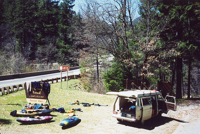
After unloading our gear and lazing around in the sun for awhile, Jesse and I headed downstream to set shuttle. Almost immediately after crossing the river the road climbed up very high and the river was soon out of sight in a deep canyon. It is always a good sign when the road runs away from the river, so we were stoked.
We took the first right turn down a small gravel road that appeared to dive down into the canyon. From here the guidebook directions grew a little hazy, but we continued on over several large humps in the road until we reached a washout. Of course, we have never let a little thing like the road being washed out stop us, so we started hiking, looking for a trail down to the river.
The road grew steadily worse, after a short distance it began to resemble a gigantic motocross track, with monster washouts and huge berms every hundred yards or so. We were doing a lot of scrambling, and there was still no sign of the river or anything resembling a path down into the canyon. Finally after about a half mile we encountered a side road that appeared to come in from above. We decided to try and find that road after finding the river as it would considerably shorten the hike. Finally after another fifteen minutes of walking we scrambled down a very steep bank and marked the take-out. There was an old campground nearby, and it appeared that you used to be able to drive down there, which we decided to try next.
It took us a half hour to hike back to the cars, and then we tried to find the second access road. We drove up and took the next right, but it soon ended with a downed tree. I suspect that was the way down to the river, but we didn't have a chainsaw to prove that theory so we turned around and set shuttle at the original road at the first washout.
We had killed over an hour figuring out the shuttle, and we were not entirely sure we could get down the river with the three hours of daylight remaining. When we got back to the put-in John was fast asleep in the sun, but when we rolled up he opened one eye and said: "We're gonna go boatin' today, right?!?"
"Oh yeah" I replied. "The shuttle road was a little messed up, so we'll have a little hike out at the end." I neglected to mention that we were going to have to rope our boats up a near-vertical erosion cliff at the take-out, then hike uphill for a mile and a half, negotiating huge washouts along the way...
We got ready and headed downstream. We were moving kind of fast, trying to avoid running out of daylight (again). The first mile or so was very scenic but mostly class II-III.
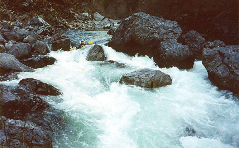
Jesse Coombs runs one of the warm-up rapids above the main gorge
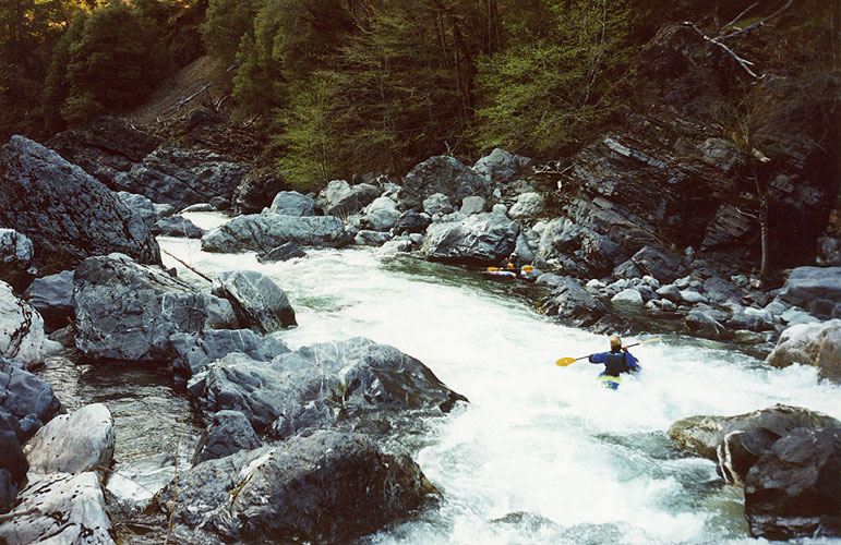
Soon however we started encountering some big boulder gardens, which were very, very good.
John and Jesse in the midst of some sweet whitewater on the Upper South Fork.
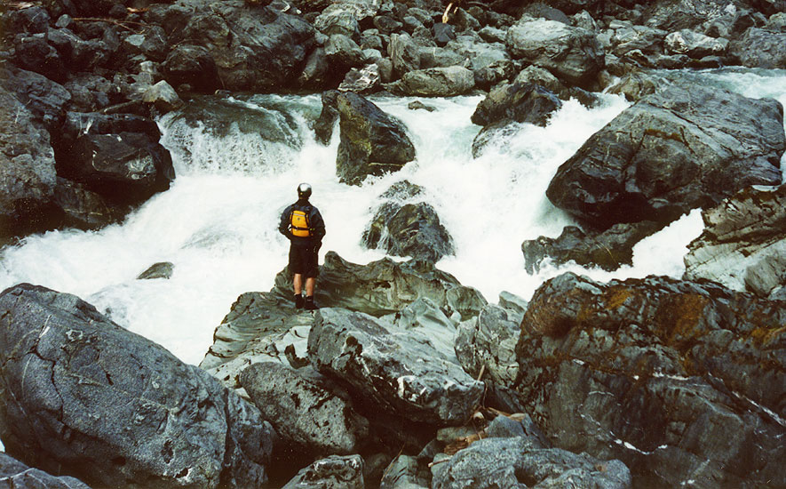
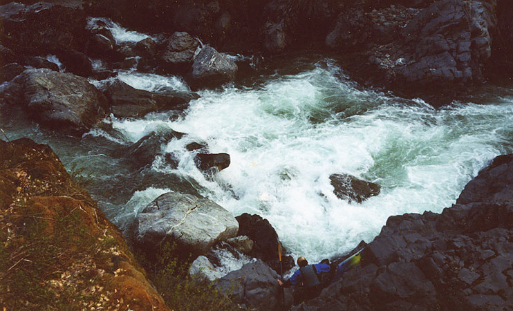
We were staying alert for the portage mentioned in the Stanley / Holbeck guide, and soon we arrived above a significant horizon line combined with a narrowing of the river. We got out to scout and John and I immediately portaged. Jesse, on the other hand, started scouting. While John and I labored over the boulders on the left, Jesse considered how he was going to run the drop, and soon he gave us a thumbs up.
Jesse scouts the recommended portage. He ran this drop cleanly just after this photo was taken, but we were more concerned with safety at that point than pictures.
While Jesse hiked back upstream John and I set up safety. It was a little difficult to do, but soon we were in place and Jesse came flying down, cruised through the meat of the drop and clawed his way out of the bottom hole after surfing for a few seconds.
Downstream the river assumed a more serious nature, with some pretty demanding drops. One boulder garden in particular stands out as the very last blind drop has a pin spot in the middle of the river. Jesse ran this final drop, but John and I barely managed to eddy out above it and portage up the steep rock wall on the right. Once we got below the final drop we could see the narrow line on the extreme right that Jesse took, but from above it had not been apparent.
John climbs around the rapid we both portaged, then wished we hadn't. Jesse ran this one down the right side, just missing the gnarly rockpile in the middle of the river by boofing to the right. From above, it looks like there is no line, but in reality it is pretty straightforward.
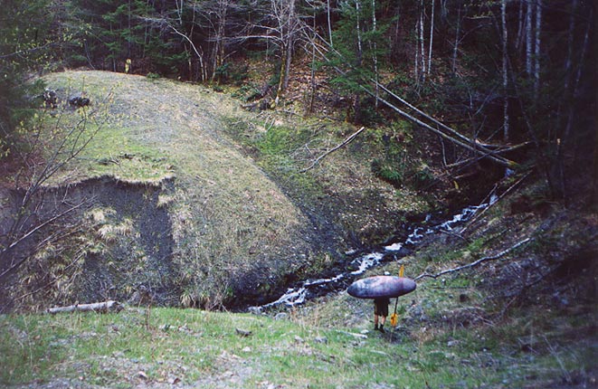
We got to the take out and started hiking. At this point it was pretty dusky and it is unfortunate there was a log blocking the road as the camping would have been excellent near the river. As it was, we had to shoulder our boats and hike. It took us about forty five minutes to reach the car, at which point it was not quite dark... Hopefully the next time we are in there area someone has taken the log out of the other road, because it would be really nice to camp near the river after running it next time!
Jesse negotiates one of the washouts on the hike out of the South Fork..
I heard recently that this run used to have a lot of wood in it, but we didn't see any on our trip down (we ran it in April 2002). Hopefully someone will snip that log off of the access road, which will make life easier for those who want to do this run in the future..