Guidebook notes: Avoid while Mt. St. Helens is erupting.

Copyright © 2005, Oregon Kayaking. No part of this page may be reproduced, linked, or copied without the express written permission of the Oregon Kayaking webmaster.
Length: 2.3 miles. Gradient: 310 fpm. Class: V. Character: Intimate wooded canyon with tight, twisty gorges.
Guidebook notes: Avoid while Mt. St. Helens is erupting.
Copyright © 2005, Oregon Kayaking.
No part of this page may be reproduced, linked, or copied without the
express written
permission of the Oregon Kayaking webmaster.
First, the creek. Hoffstadt is very exciting, winding through an endless series of tiny gorges with more waterfalls and ledges than you can count. This is definitely some of the best creekboating the Northwest has to offer.
The access for Hoffstadt, on the other hand, has changed recently for the worse. Weyerhaeuser (this is the correct spelling..) timber company (who owns the land around Hoffstadt) has closed off both of the spur roads accessing this run. That isn't such a big deal for the put-in, because the hike is relatively easy.
The take-out, on the other hand, is terrible. You have two options: A punishing slog up the canyon wall to the bridge, or a longer, less steep hike up the old access road. You have to gain 400-500 feet of elevation either way, so get ready for some serious aerobic conditioning at the end of the day. On this trip, we opted for the hike up to the bridge.
One of the most intriguing aspects of any visit to Hoffstadt is nearby Mt. St. Helens, the Pacific Northwest's very own weapon of mass destruction. St. Helens is the only active volcano in the continental United States, and we are very proud of our seething little vixen!
In 1980 Mt. St. Helens experienced a closely spaced series of six explosive eruptions. The top 1,300 feet of the mountain was vaporized, killing 57 people and depositing 200 million cubic yards of mud and debris into the surrounding river channels. Pretty much everything in the immediate vicinity was annihilated and ash was spread across the entire planet.
I remember that I was coming back down to Oregon from Canada with my parents when St. Helens blew, and on Interstate Five was it was like a snow blizzard, except instead of snow it was ash. I thought it was pretty cool, but I was just a kid at the time.. It took many years for the local landscape to recover from the devastation in the wake of this eruption.
Recently, St. Helens has re-awakened, much to the delight of local volcano enthusiasts!
Hmm.. isn't the lava dome on Mt. St Helens growing right now?
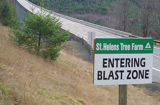
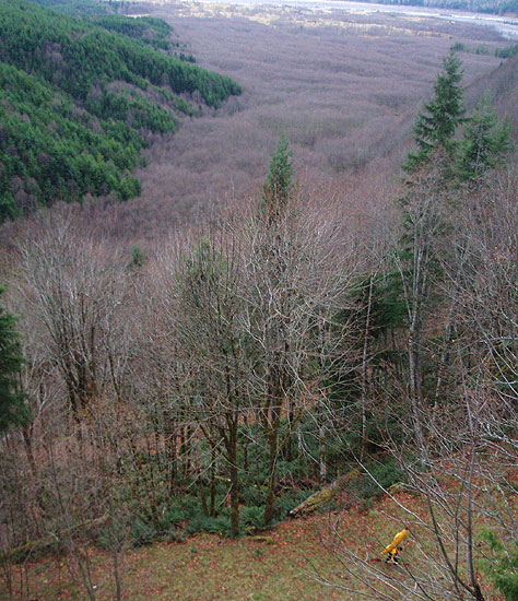
Hoffstadt Creek (viewed in the background) is within the Mt. St. Helens 'blast zone'.
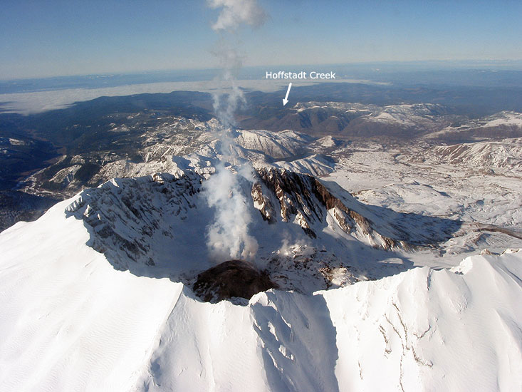
A photo of the Mt. St. Helens crater, taken from the southeastern side of the mountain by the USGS on January 3rd, 2005.
The flattened valley in the right-middle of the photos marks the main mudflow path for Mt. St. Helens, so you might get more than you bargained for if you are on Hoffstadt creek when St. Helens goes nuclear again..
Photo credit: Ken McGee of the United States Geological Survey Cascades Volcano Observatory. ( 1/3/2005 )
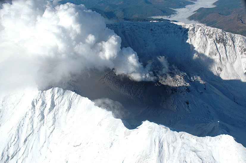
A close-up photo of the Mt. St. Helens crater, taken from the eastern side of the mountain by the USGS on October 20th, 2004.
Photo credit: Dave Schneider of the United States Geological Survey Cascades Volcano Observatory. ( 10/20/2004 )
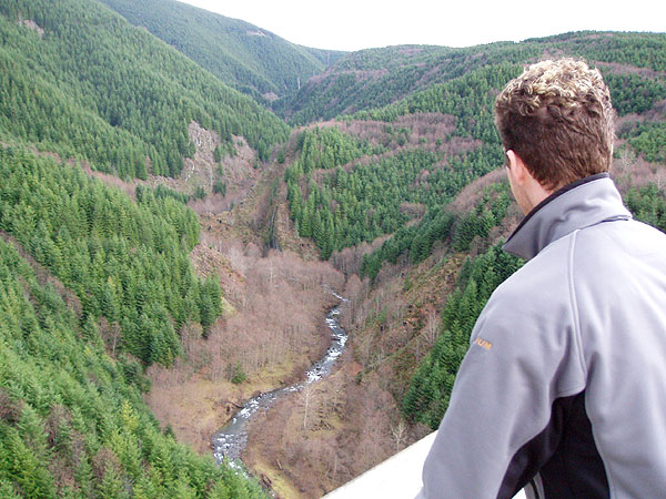
We spent a little time at the bridge peering down into the canyon, absorbing the scale of the take-out hike, which turned out to be even worse than we had imagined..
"We gotta hike up from down there?!?" James Bagley Jr. looks up into Hoffstadt Creek drainage while pondering the hideous take-out hike from the creek.
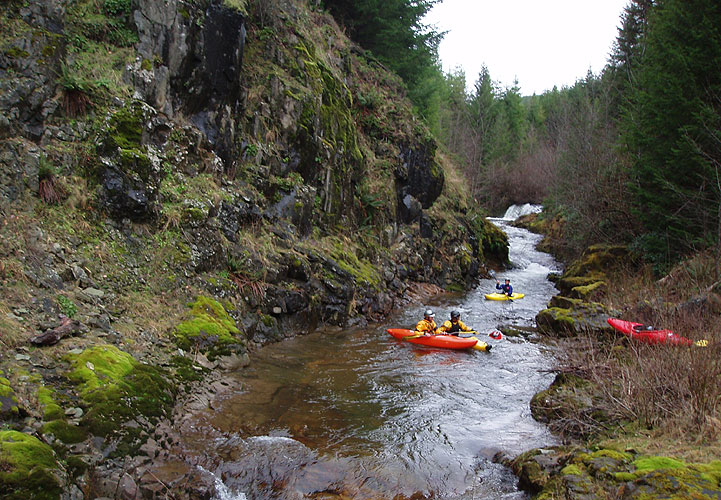
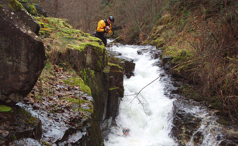
Below the put-in the creek is all bedrock and very narrow, twisting and winding down the narrow canyon. The first drop is a fun ten-foot ledge called 'Bouncer', which is easy and clean on the right hand side. Below Bouncer are more rapids of a similar nature; the creek is all bedrock, no boulders to speak of, at least in the first couple of miles..
A typical view up Hoffstadt. There are lots of ledges and falls on this run, the vast majority of which are ultra-clean.
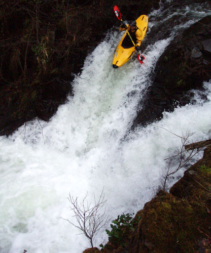
Immediately downstream from this portage is split falls, one of the biggest vertical drops on the run. You can scout this drop during the portage, just leave your boats and hike a short distance downstream to the falls. The falls is very clean, with a good line down the right.
Pete Giordano drops the split falls.
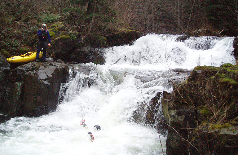
Be very careful above this drop; getting to the portage eddy can be challenging. Just upstream of Gnar there is a ten-foot ledge with a clean line down the right side. Below the ledge is a 20-foot wide pool with an eddy against the right gorge wall. Below the ledge the creek takes a 90-degree turn to the left and enters a narrow flume down the left wall with a small portage eddy on the left-hand side and an eight-foot tall boulder just downstream of the eddy. The boulder marks the entrance to Gnargasm. There is a small island on the downstream side of the pool, where you can scout the move into the eddy above Gnargasm. (It should be noted that you cannot portage from the island. You can only portage from the eddy.)
If you miss the portage eddy, there are no second chances; you are going to run Gnargasm blind. This is not recommended, but it has been done successfully in the past. A few years ago a local group was running this creek for the first time and the first paddler down missed the eddy and ended up being swept over Gnargasm. He made it to the bottom without major injuries, but the next guy (who scouted the drop before running it) broke some ribs running the drop. Remember, if you get blown into Gnargasm run the left side through the first part, then drive hard right once you get over the first series of drops. The final ledge on the left hand side (the last big horizon line) lands on a bedrock shelf and should be avoided.
The higher the water gets, the harder it is to make the eddy above Gnargasm. This is worth remembering if you get to the take-out bridge the creek is big and muddy.
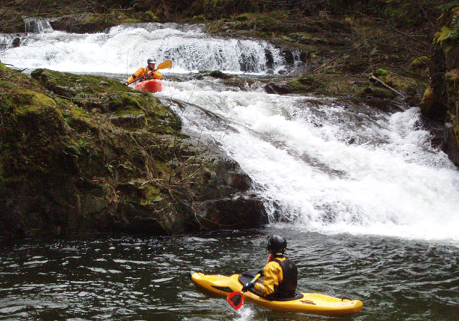
Pete Giordano watches as Jesse Coombs runs some typical drops on Hoffstadt. These drops are located immediately downstream of Gnargasm.
James films as Pete disappears into the bottom hole on the big double falls.
Jon Fowlkes watches as James Bagley Jr. gets swallowed up by one of the narrow slot-drops.
As described at the beginning of the report, the take-out is pretty demanding. If you take out at the bridge like we did, look for a trail just downstream from the bridge that has some small, knotted fixed lines that will help you up the first, near-vertical pitch. Once you reach the flat spot at the first bridge piling, stay close to the bridge because the hiking is much easier under there..
Pete Giordano toughs it out on the last pitch of the long, steep hike up from the creek at the end of the day.
This is the most physically demanding take-out I have ever done.
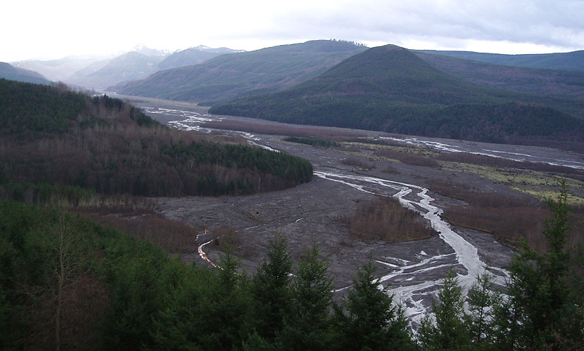
( taken from the highway bridge. The Mt. St. Helen mud flows are visible at the top of the photo )
The main mud flow from the 1980 Mt. St. Helens eruption. Hoffstadt Creek comes in on the upper-most left hand side of the image, joining the NF Toutle, the river that follows the mudflow.
( Mt. St. Helens is obscured by the clouds in the back of the image. )
COMMENTS: Don't run this creek unless you are experienced on steep class V runs. Eddies are scarce, so be careful at some flows. The creek itself actually goes pretty quickly, you have to scout a fair amount but it is fairly easy to move around on Hoffstadt because it is all rock and no undergrowth or trees, etc. That said, I think it might be very hard to portage in a few places if you were so inclined and the eddies get scarce at higher flows. There are probably 4-5 log portages right now, so keep a sharp eye out.
Be careful above Gnargasm, which is an accident just waiting to happen.
FLOWS: I don't know a reliable gauge for this creek. We were in the range as indicated in the guidebook ( about 3,600 on the Toutle at Tower Road gauge ) but we had very low water. I think about two or three times the flow we had would be a good medium flow, but I'm not sure what that corresponds to on any gauge. I think the key thing is that Hoffstadt flashes (much like Oregon's Sardine Creek) so you have to catch it immediately after or during a big rain storm.
If anyone has good beta on what is an indicator for flows on this creek, please let me know!
| More USGS photos St. Helens, before - during - after the original 1980/81 eruptions. | |
|
Mt. St. Helens, one day before and shortly after the series of eruptions. Both photos were taken from the same place on Johnston's Ridge. Photo credits: Harry Glicken, USGS. |
|
|
Mount St. Helens on 5/17/1980, one day before the eruption. Taken from Johnston's Ridge. 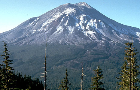
|
Mount St. Helens, taken 9/10/1980. Taken from the same spot on Johnston's ridge. 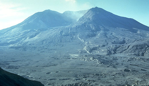
|
|
The first eruption of Mt. St. Helens, May 18, 1980, at 8:32 a.m.
Photo taken by Austin Post, USGS. 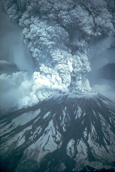
|
|