McDowell Creek
Location: Western Oregon, Willamette Valley near Canyon Creek, Oregon
Class: IV+ to V, depending on flows
Gradient: 200 fpm
Nature: Located within a state park with hiking trails for access.
Torture Factor: Low
Click here to see a video of a trip down this creek, by James Bagley Jr.

Copyright © 2002-2006, Oregon Kayaking, James Bagley Jr, and EJ Etherington.
No part of this page may be reproduced, linked, or copied without the
express written
permission of the Oregon Kayaking Webmaster.
There is a thin band of rock that lines the eastern side of the Willamette Valley that gives rise to a series of impressive waterfall-studded creeks that seem oddly out of place in the diminuative hills clustered along the western foothills of the Cascades.
Upper Silver Creek, Upper Butte Creek, Stout Creek, and Mcdowell Creek all cascade impressively over this band, and it was to Mcdowell we headed last weekend to sample a few new ledges and falls.
Mcdowell Creek isn't hard to find, just follow the signs east of Lebanon to Mcdowell Creek Park. Dan Coyle is thought to own the first descent of Mcdowell, running it solo in 1997. Dan later returned to make the first descent of Majestic Falls, the monster drop with a shallow landing at the put-in.
( To read about Dan's epic first descent of this intimidating drop, click here.)
Because Mcdowell has such a low drainage, this run is almost entirely rain-fed. Pete Giordano, Jesse Coombs and myself headed up to run the creek towards the end of February after intermittent rainstorms. Later we agreed more water would have been better, but in a few spots that would have made the run a bit dangerous.
We got to the put-in and examined Majestic Falls. Majestic thunders forty feet over a broken ledge into a pool that gets shallow very quickly as you move away from the base of the falls. No one has hit bottom here yet, but there have been some epic lines ( see Dan's account of his first descent, above.. )
Jesse wanted to run Majestic, but decided not to after we told him the landing was shallow. None of the rest of us seriously considered running it, but we scouted it anyway and talked about what happened to Dan when he did the first descent. The falls has been run since then by at least one other person that I know of ("Fireman" Dave Mcneil of Eugene) but it was too big and nasty for any of us on this particular day.
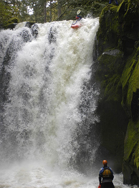
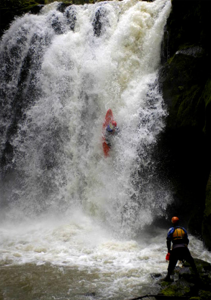
In 2006 a group of Corvallis boaters went up to Mcdowell with more water and Chris Korbulic fired off Majestic. He ended up penciling in and didn't hit the bottom, so I guess it is at least one 'Jefe' deep..
Chris Korbulic fires off Majestic Falls ( Photos taken on a 2006 trip )
photos by EJ Etherington
Below Majestic the creek tumbled down through some smaller rocky drops until we dropped under the bridge and entered a short, tight section that had several logs jammed in it. Jesse charged down into one log and actually did a full-on barrel-roll over it, which was the first time I have ever seen anybody do that on purpose..
Below the logs was the first big horizon line and we clawed our way into an eddy above it. I think it would be very difficult to stop above this drop at higher water, so stay alert!
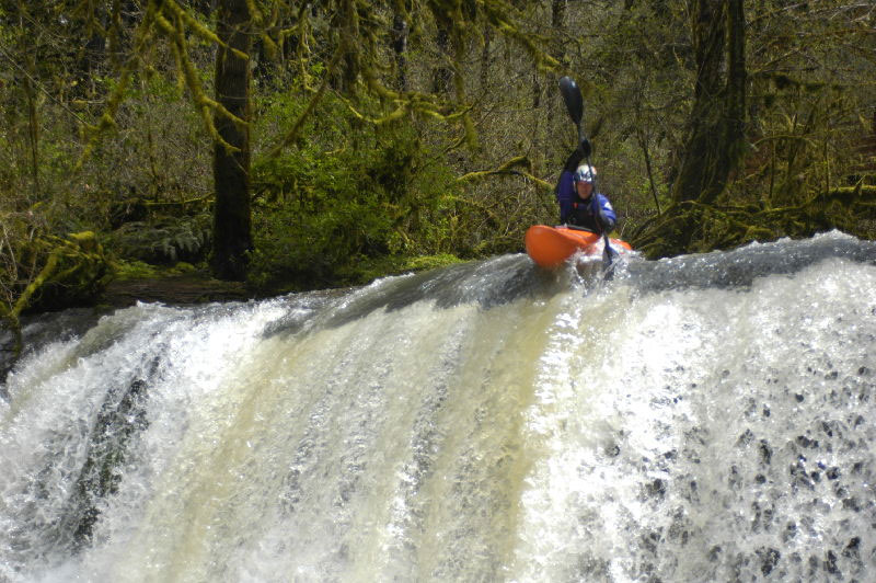
This first falls drops about 14 feet into a large pool. This drop is a little sketchy because most of the water is funneled down into a crack on the left, where it crashes into and over broken ledge at the bottom. The right side boof is the only safe line, and it worked well on this day.
Pete Giordano probes the first falls. If you look carefully you can see the broken-up ledge that most of the water pours onto on the river-left side. A missed line here could result in a serious injury, severe pin, or both.
Below this drop we encountered another log above a foot bridge and then the creek started accelerating down over a smooth rocky slide. I could see that the water was dropping out of sight around the corner below, so I clawed my way onto the shallower left side of the channel and grabbed a tree limb to stop. Pete was not so lucky and was swept around the corner, dropping out of sight. I got out of my boat and grabbed Jesse and we hopped out to scout. For a second we couldn't see Pete, but then he popped into sight and gave the ok. The drop turned out to be pretty trivial, but it didn't look that way from above. (at higher water there would be no stopping above this drop, which goes around a blind corner.)
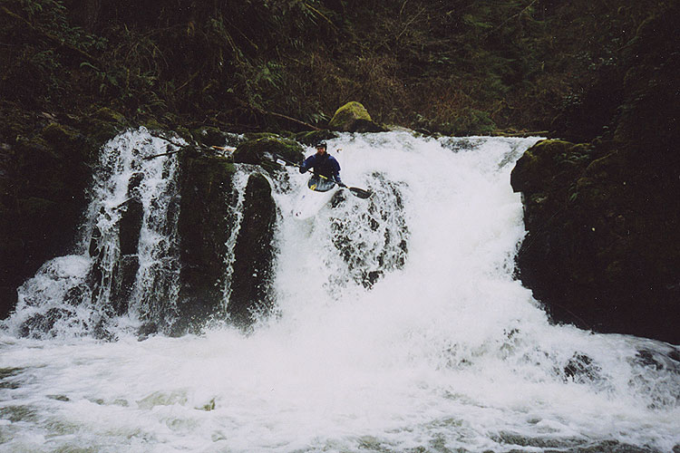
Immediately below this drop was a great sequence of three ledges dropping about twenty feet total. The first drops about ten feet, which leads to a long slide that twists to the left over a second ledge, then a final vertical six-foot drop.
James Bagley Jr. runs the first in a series of ledges and slides ( taken on a later trip )
photo by EJ Etherington
Jesse Coombs cruises down a fun series of ledges on Mcdowell

Below these ledges the creek mellowed temporarily and then dropped over another fun, dome-shaped ledge and several smaller ledges before mellowing out to the take-out bridge. We were actually pretty pleased with this run overall, and though we could have done without the wood (and used a bit more water) it was a pretty good day of boating.
After taking off of Mcdowell (the run is only about 1.3 miles so it goes pretty quick) we headed up to run the Soda River, but that is another story...
Flows, Access, and Map:
The turn-off for Mcdowell is between Lebanon and Sweet Home a half hour east of Corvallis. Once you turn in Sweet Home, the park is about nine miles upstream from there.
Flows (provided by Dan Coyle): "The level in the South Santiam above foster was 3200 cfs when I ran the falls. The South Santiam is the best gauge river for this creek with an estimated minimum of 1400 in the South Santiam, although I have done it lower.
This creek is in the very foothills and reacts to weather more like the coast range so it wouldn't be wise to depend on snowmelt to do anything significant for this creek. On the other hand you could probably count on cold showers to bring the level up substantially relative to other Cascade runs."
The section we run is marked in red. All access to this run is via footpaths within the park. You start hiking at the state park parking lot and keep going until you reach the footbridge across the creek just below Majestic Falls.