Of course, at one point when you are driving along the upper section the road climbs up high and runs away from the creek, which is always a good sign. We later found out from a guy Pete knows that there is actually a half-mile section of steep rapids on the Upper Soda Fork, so we decided to check it out.
There are two distinct sections on this creek, and they couldn't be more different. Both are short, but packed with rapids. Lower Soda Fork ( see access and description at the end of this report ) is class III and IV and is usually run at much higher water than the upper. The lower is a super-fun, low-stress roller-coaster ride down a series of non-stop slides and ledges up to eight feet tall. The creek is wide and is quite scenic.
The Upper Soda Fork couldn't be more different, and that's where our story begins..
On this particular adventure Pete and I were joined by Jon Fowlkes out of Portland, Gabe Flock out of Eugene, and the Corvallis crew, consisting of EJ Etherington, James Bagley Jr., and Mike Long.
Gabe had actually run the Soda Fork top-to-bottom many years ago with Dan Coyle at very, very high water, and could only vaguely recall getting annihilated in a massive hole on the lower section. He hadn't been back since, and was looking forward to seeing the creek at under 50 mph.
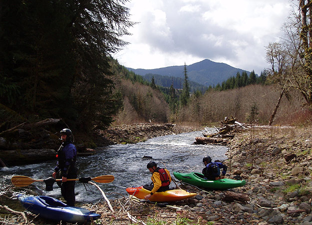
If we didn't know better, the put-in would have turned us away. Much like Canyon Creek Oregon, the put-in for the Upper Soda Fork is deceptively placid and loggy, concealing the fact that a few hundred yards downstream the creek tilts on edge and changes instantly from a sleepy little stream to a stomping, frothing pile of boulder-choked rapids.
From left to right, Gabe Flock, Jon Fowlkes, and Mike Long at the put-in for the upper section of the Soda Fork. Much like Canyon Creek Oregon, the creek at the put-in is deceptively calm compared to what waits just downstream..
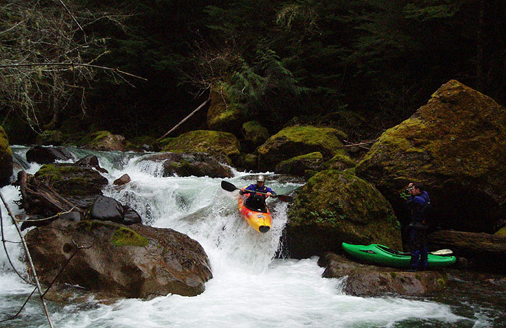
There are no warm-up rapids on the Upper Soda Fork. We rounded a corner and the creek just dropped out of sight! We had to portage the entrance to the first rapid on the left because of wood, and then ran the meat of that rapid from that side, starting with a fun boof in the middle of the creek and then dropping into a narrow, powerful slot on the creek-left side which produced some exciting tailstands..
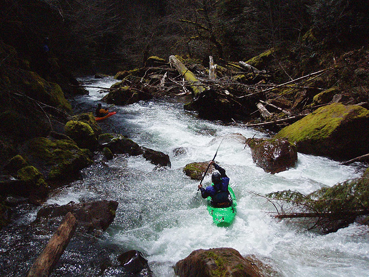
Mike Long lines up for the boof on the entrance rapids for the upper Soda Fork. Just downstream, Jon Fowlkes gets ready to probe a steep, narrow, slot-drop that resulted in a few tail-stands..
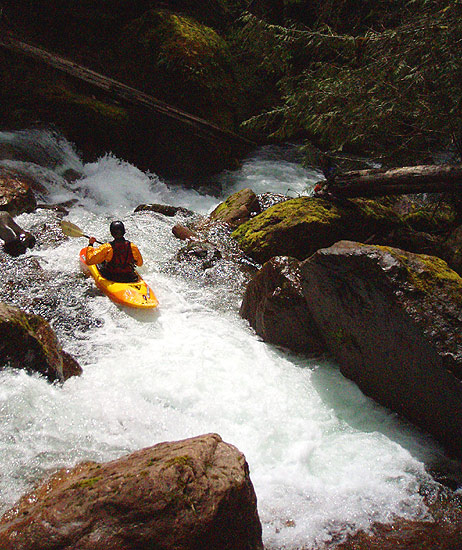
Just below the entrance rapid the creek disappeared with a tremendous roar over a large horizon line. We eddied out against the wall on the left side, then ran the short ledge at the top of the rapid on the left hand side so we could scout the main rapid.
It turns out that scouting ( and portaging! ) this rapid is MUCH easier on the creek-right side, so be sure to stop well upstream of this rapid when you run this section! Gabe and I instantly decided to portage this rapid once we took a look at it, so we groveled down the difficult creek-left portage line ( all the while looking at the right side of the creek and wishing we were over there! )
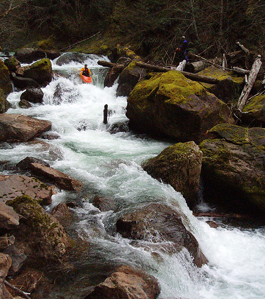
Eventually everyone but Mike and Jon decided to portage, so we set up safety ( this rapid is so large we had three people positioned with ropes at different spots along it! ) while Mike Long probed the drop without problems. Jon went next and had a nice line as well..
Jon Fowlkes drops into a chunky rapid on the Upper section ( about half of the rapid is visible in this photo ). Scouting and/or portaging this rapid is easy on the right, difficult on the left, so stop well upstream of this one!
The creek never really stopped for the next half-mile. When you have a chance to look around, the scenery is pretty nice, with large, mossy boulders and lots of trees, but the creek had our full attention!
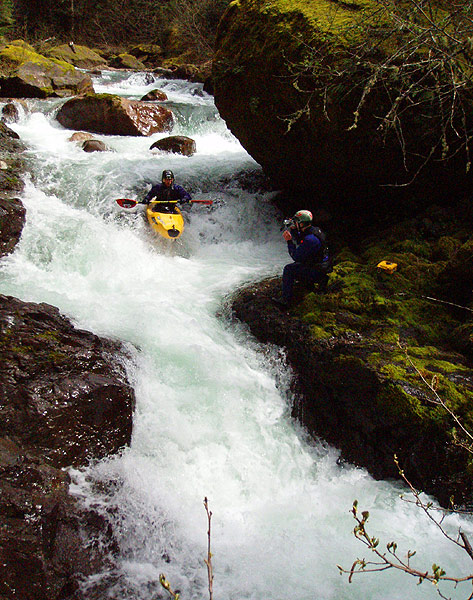
Jon Fowlkes runs a narrow, twisty series of drops downstream..
The next significant rapid ended with most of the water pouring onto a boulder on the right. I went first and didn't go far enough to the left. I fell into the boulder and took a brutal hit to my elbow ( luckily I wear heavy-duty elbow pads ) but paddled away ok. I'm pretty sure I would've seriously injured or broken my arm if I hadn't been wearing my pads!
After watching my horrible-looking line, everyone else boofed hard to the left and had no problems on this one..
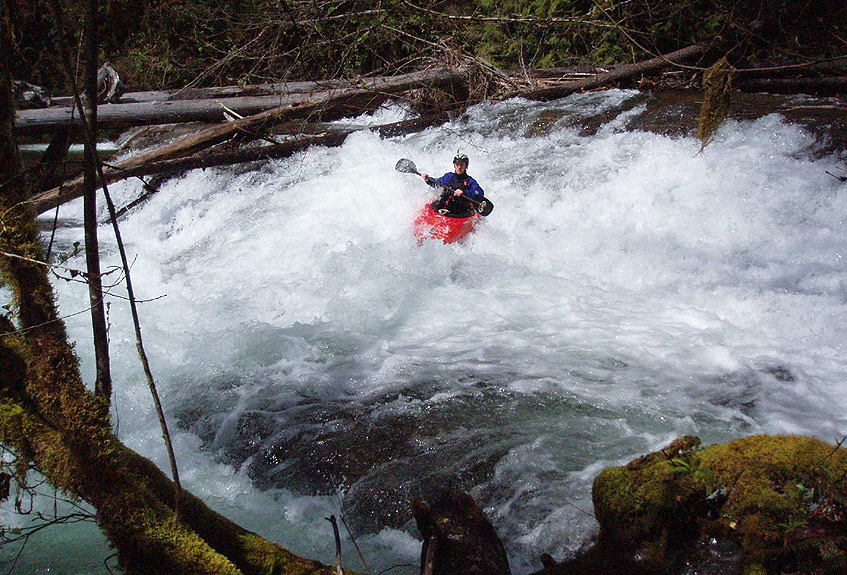
EJ Etherington boofs the elbow-breaker rapid..
Downstream the gradient cooled off slightly but the rapids were still really good..
Pete Giordano styles a fun series of drops downstream of elbow-breaker.
There is a large log-jam that looked marginally runnable at the end of the steep section, but we all decided to walk around it on the right hand side. Below here the rapids disappeared and the creek was pretty much class II all the way to the take out bridge.
Unfortunately for us, we also decided to run the lower section, which turned out to be MUCH too low. We scraped our way down, wishing we had double the flow, until we reached the take-out on the South Santiam.
James Bagley Jr. runs a typical slide on the lower ( class III-IV ) section of the Soda Fork. We had about 1500 cfs on the South Santiam at Cascadia gauge, which is medium-low for the upper but much!! too low for the lower section of the Soda Fork. See description below for details.
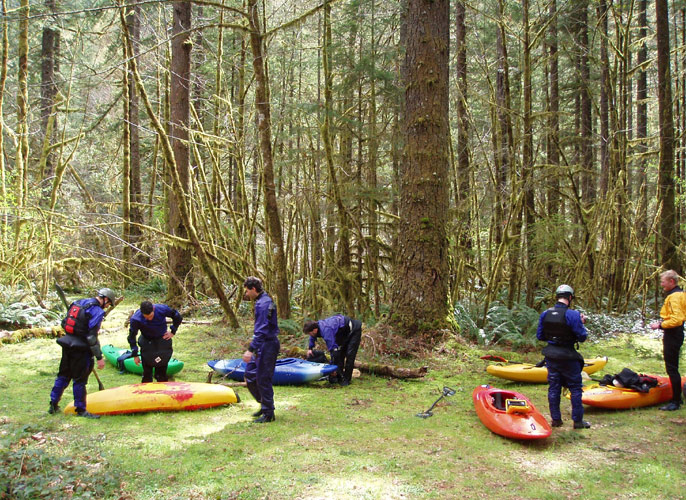
Team Ever-Ready (for a debacle) at the take-out for the Soda Fork along the South Santiam River.
ACCESS, FLOWS, AND HISTORY:
HISTORY: The first known descent of the Soda Fork was made by Corvallis-based Eric Brown and Arthur Koepsell in 1988.
UPPER SODA FORK:
Class: V
LOWER SODA FORK:
Class: III-IV
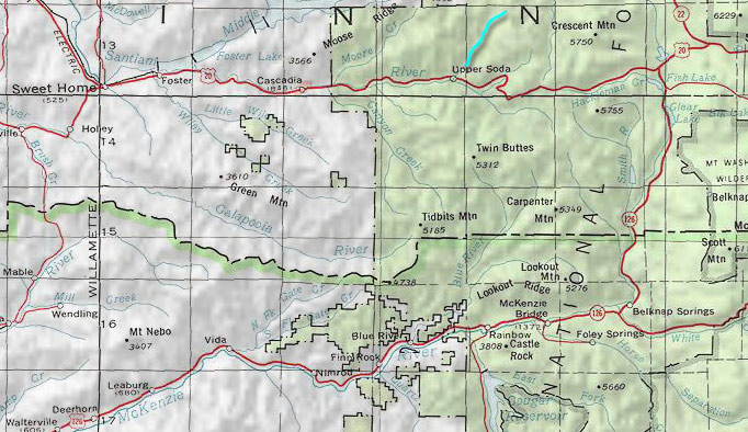
A map showing the location of the Soda Fork of the South Santiam relative to Canyon Creek Oregon and Sweet home. The tiny hamlet of Upper Soda marks the confluence of the Soda Fork and the South Santiam.
Length: 1.37 miles
Average Gradient: 206 fpm. ( The majority of this gradient is lost in a single half-mile which has a gradient of 300 fpm. )
Description: Narrow, powerful, congested boulder gardens similar to those found on Canyon Creek, Oregon. Much too short for a single trip, this section is usually combined with a run down nearby Canyon Creek, Oregon.
Flow recommendations: This section can be run much lower than the Lower Soda Fork because it is so narrow. High water is intense.
Minimum recommended flows: 1500 cfs in the South Santiam at Cascadia gauge after or during a large rainstorm. Can be run much higher if you are familiar with the creek, as the crux section becomes a single gigantic rapid.
Access: From Sweet Home, drive east on Highway 20 along the South Santiam until you reach the tiny hamlet of Upper Soda. Turn left just before you cross the bridge over the Soda Fork and continue up the road along the Soda Fork for 2.25 miles until you come to the second bridge across the creek. Put in here, be sure and check out the gigantic, six-foot diameter old-growth Douglas Fir next to the bridge, pretty amazing! Take out at the put-in for the Lower Soda Fork, unless you have over 3000 cfs on the South Santiam gauge, which is enough water to continue down to the South Santiam, using the take-out described below.
Length: .88 miles
Average Gradient: 67 fpm.
Description: Non-stop bedrock slides and ledges up to eight feet tall. Very fun! Too short for a single trip, this run is usually combined with nearby runs on the South Santiam.
Flow recommendations: Don't run this one with low water, it is very wide and doesn't ever channelize.
Minimum recommended flows: 3000 cfs in the South Santiam at Cascadia gauge after or during a large rainstorm.
Access: From Sweet Home, drive east on Highway 20 along the South Santiam until you reach the tiny hamlet of Upper Soda. Turn left just before you cross the bridge over the Soda Fork and continue up the road along the Soda Fork for .88 miles until you come to a bridge. Put in here. The take-out is tricky because the landowners in the tiny hamlet of Upper Soda have posted 'No Trespassing' signs all over the place at the highway bridge. This means you have to continue down to the South Santiam and take out on that river. To reach the take-out, turn right onto highway 20 and drive west about 200 yards down the South Santiam until you see a nearly invisible road going into the woods on the left. This road leads to the meadow shown in the last photo of this report. There are a couple of nice fisherman trails down to the South Santiam from there.